Configuration Options
ReverseGeocodeUSLocation Configuration Options
The following table lists the configuration options for ReverseGeocodeUSLocation.
| optionName | Description |
|---|---|
|
Dataset |
The name of the database that contains the data to use in the search process. |
|
SearchDistance |
Specifies the radius, in feet, that ReverseGeocodeUSLocation searches for matches. The allowable range is 0 - 5280 feet. Default = 150 feet. |
|
FindClosestPoint |
Enables matching to the nearest point address within the search radius, rather than to the closest feature - such as a street segment or intersection as well as point addresses. Note: This option requires that at least one streets data set and
one points data set are loaded; otherwise, the match will be
made to the closest feature.
|
|
FindNearestAddress |
Specifies whether ReverseGeocodeUSLocation should find the nearest interpolated address to the input geocode.
Note: You can use this option with the FindNearestIntersection option to geocode to both
addresses and intersections.
|
|
FindNearestUnranged |
Specifies whether ReverseGeocodeUSLocation can match to a street segment that does not have a number range. This option is active when FindNearestAddress=Y.
Note: If you are using the point-level data option, ReverseGeocodeUSLocation ignores the
Nearest Unranged option.
|
|
FindNearestIntersection |
Specifies whether ReverseGeocodeUSLocation should find the nearest street intersection to the input geocode.
Note: You can use this option with the FindNearestAddress
option to geocode to both addresses and intersections.
|
|
Offset |
Specifies the offset distance from the street segments. The allowable range is 0 - 5280 feet. Default = 50 feet. The offset distance is used in street-level geocoding to prevent the geocode from being in the middle of a street. It compensates for the fact that street-level geocoding returns a latitude and longitude point in the center of the street where the address is located. Since the building represented by an address is not on the street itself, you do not want the geocode for an address to be a point on the street. Instead, you want the geocode to represent the location of the building which sits next to the street. For example, an offset of 40 feet means that the geocode will represent a point 40 feet back from the center of the street. The distance is calculated perpendicular to the portion of the street segment for the address. Offset is also used to prevent addresses across the street from each other from being given the same point. The diagram below shows an offset point in relation to the original point. 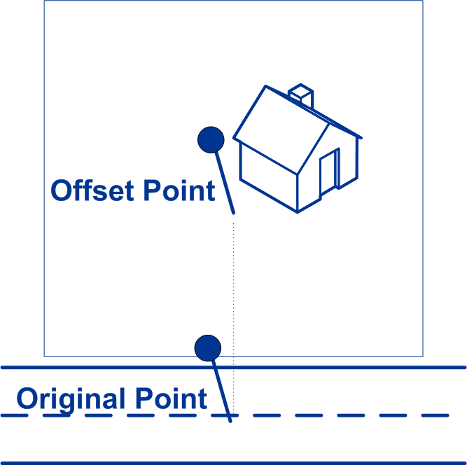
Street coordinates are accurate to 1/10,000th of a degree and interpolated points are accurate to 1/1,000,000th of a degree. |
|
Squeeze |
Specifies the distance, in feet, to squeeze the street end points in street-level geocoding. The range is 0 -2147483647 feet. Default = 50 feet. The following diagram compares the end points of a street to squeezed end points. 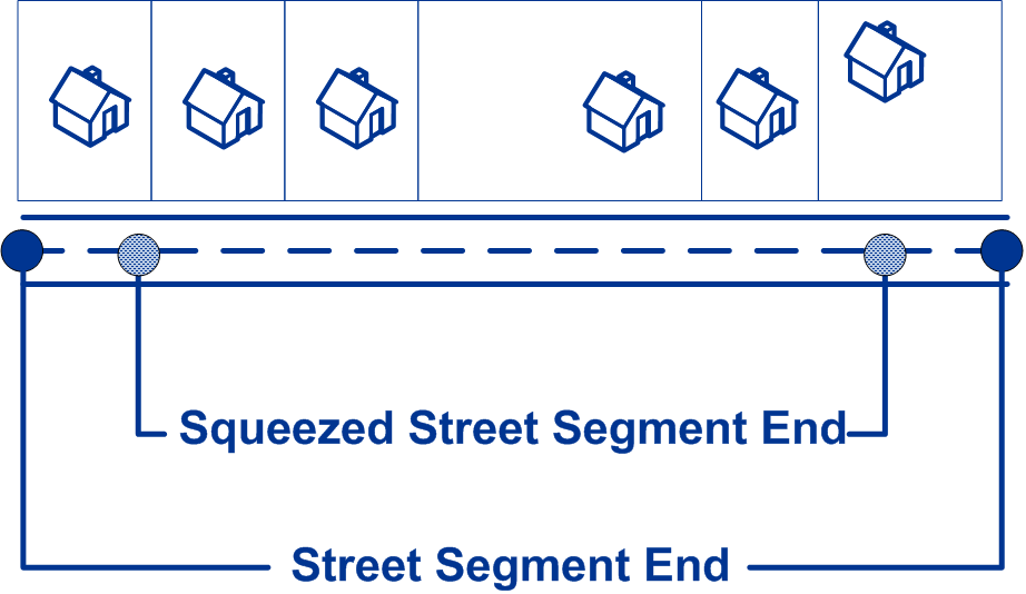
|
|
LatLonFormat |
Specifies the format to use for returned latitude/longitude.
|
|
InputLatLonFormat |
Specifies the format to use for input latitude/longitude.
|
|
RetrieveElevation |
Specifies whether ReverseGeocodeUSLocation returns the elevation of the address. Elevation is the distance above or below sea level of a given location. The elevation is returned in the Elevation output field, which is part of the Latitude/Longitude output group. Note: This option requires that you have licensed and installed the
Centrus Premium Points database. Elevation data is not available
for all addresses. See the coverage map included with the points
database.
|
|
RetrieveAPN |
Specifies whether ReverseGeocodeUSLocation should determine the address's APN (assessor's parcel number). The APN is an ID number assigned to a property by the local property tax authority. The APN is returned in the APN output field, which is part of the Census output group. Note: This option requires that you have licensed and installed the
Cenrus Enhanced Points or Centrus Premium Points database. APN
data is not available for all addresses. See the coverage map
included with the points database.
|
|
FIND_APPROXIMATE_PBKEY |
When FIND_APPROXIMATE_PBKEY is enabled, if an address match is not made to Master Location Data (MLD), but to a different dataset, the pbKey™ unique identifier of the nearest MLD point located within the search distance is returned. To distinguish when a fallback pbKey™ unique identifier is returned, the PBKey return value contains a leading character of "X" rather than "P", for example: X00001XSF1IF. Note, all of the other fields returned for the address match, including the geocode and all associated data, reflect the match results for the input address. The fallback pbKey™ unique identifier can then be used for the lookup to the GeoEnrichment dataset(s), and the attribute data for the fallback location is returned for the match. Note: This option requires that you have licensed and installed the
Master Location Dataset.
For more information, see PBKey Fallback. The search distance for the nearest MLD point is configurable using the ReverseGeocodeUSLocation SearchDistance field. The allowable range is 0 - 5280 feet. Default = 150 feet.
|
PBKey Fallback
A pbKey™ unique identifier is returned when a match is made to the Master Location Dataset (MLD). This field is a persistent identifier for an address. The pbKey™ unique identifier serves as a lookup key with Pitney Bowes GeoEnrichment datasets to add attribute data for an address. Depending on the GeoEnrichment dataset(s) you install, the attribute data can include property ownership, real estate, census, consumer expenditure, demographic, geographic, fire and flood protection, and/or telecommunication and wireless systems information and more. Some of these datasets return point location specific data, such as property ownership and real estate, whereas others provide polygonal-based data, for example, fire and flood protection, which can identify flood plains, wildfire or rating territories.
When using PBKey Fallback, if an address match is not made to Master Location Data, but a match is made to a different dataset, the pbKey™ unique identifier of the nearest MLD point located within the search distance is returned. To distinguish when a fallback pbKey™ unique identifier is returned, the PBKey return value contains a leading character of "X" rather than "P", for example: X00001XSF1IF. Note, all of the other fields returned for the address match, including the geocode and all associated data returns, reflect the match results for the input address. The fallback pbKey™ unique identifier can then be used for the lookup to the GeoEnrichment dataset(s), and the attribute data for the fallback location is returned for the match.
The relevance and accuracy of the returned attribute data using a PBKey Fallback location is highly dependent on the type of GeoEnrichment data, as well as the PBKey Fallback search distance. PBKey Fallback is intended for use with GeoEnrichment datasets that have polygonal-based data, rather than point-specific data. For example, the PBKey Fallback option may be suitable for determining the FEMA flood zone for a given location using the Flood Risk Pro GeoEnrichment dataset since it contains data that represents a polygonal region rather than a single coordinate. However, it is important to note that the accuracy of the returned data would very much depend on the size and nature of the individual polygonal features described in the GeoEnrichment data, combined with the search distance used to locate the nearest Master Location Data point. The search distance is configurable with an allowable search radius of 0-5280 feet and a default value of 150 feet.