Geocoding Options
Geocoding is the process of determining the latitude/longitude coordinates of a given address. Address coordinates are used as the basis for determining the tax jurisdictions for an address. Geocoding options control how AssignGeoTAXInfo determines address latitude/longitude coordinates.
| optionName | Description |
|---|---|
|
Latitude/Longitude placement: These options can be set for the geocode result. |
|
|
LatLongOffset |
Indicates the offset distance in feet from the street center line. The offset distance is used in street-level geocoding to prevent the geocode from being in the middle of a street. It compensates for the fact that street-level geocoding returns a latitude and longitude point in the center of the street where the address is located. Since the building represented by an address is not on the street itself, you do not want the geocode for an address to be a point on the street. Instead, you want the geocode to represent the location of the building which sits next to the street. For example, an offset of 40 feet means that the geocode will represent a point 40 feet back from the center of the street. The distance is calculated perpendicular to the portion of the street segment for the address. Offset is also used to prevent addresses across the street from each other from being given the same point. The diagram below shows an offset point in relation to the original point. 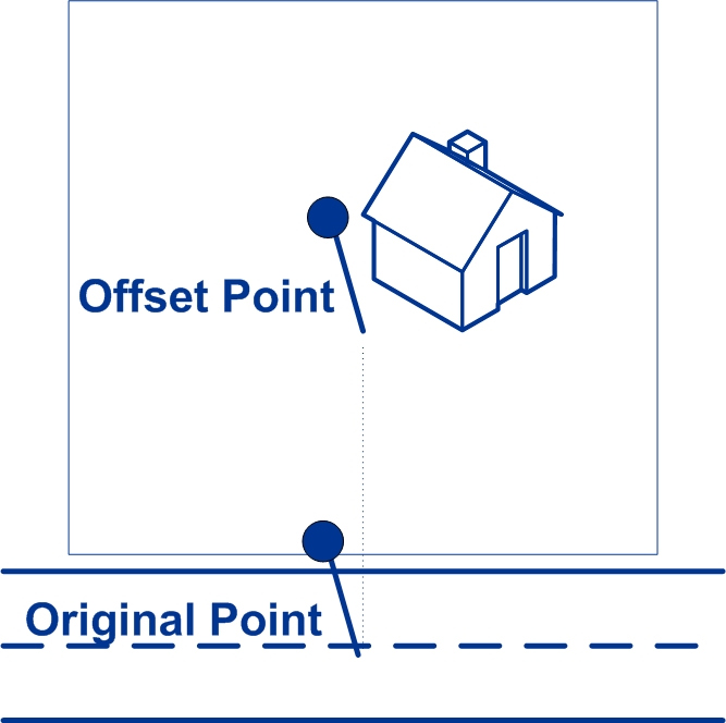
|
|
Squeeze |
Specifies if the street end points should be "squeezed" when determining the geocode of an address in street-level matching. When Squeeze is enabled, both street and end points are moved closer to the center of the segment by 50 feet. The diagram below compares the end points of a street segment to the squeezed end points of a street segment. 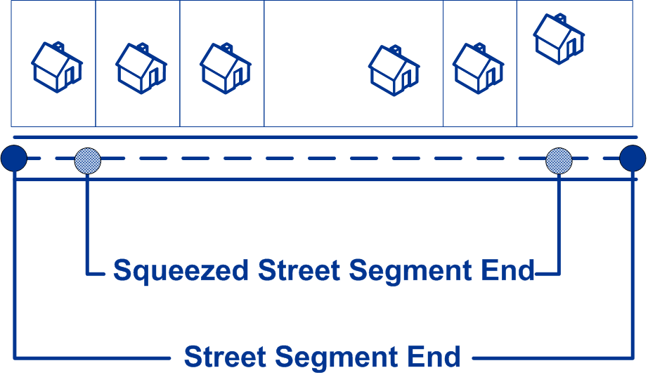
|
|
LatLongFormat |
Indicates the desired format for the returned latitude/longitude. One of the following:
|
|
Expanded Geocoding options: These options enable additional geocoding functionality. |
|
|
GsEnableAddressPointInterpolation |
Address point interpolation uses a patented process that improves upon regular street segment interpolation by inserting point data into the interpolation process. Note: This feature is only for use with point-level
geocoding.
A match is first attempted using the loaded points data. If an exact point match is found in the points data, then searching ceases and the point match is returned. If an exact point match was not found, the Enterprise Tax Module attempts to find high and low boundary address points to use for address point interpolation.
|
|
Minimum geocode quality |
|
|
GsEnableGeographicFallback |
The default search does not perform a search of geographic centroids. When enabled, the Geographic Fallback feature locates the first city, county and/or state centroid, and then matches from the set of possible matches found.
|
|
GsEnableStreetCentroid |
If an input street address cannot be found using the street number and name, the Enterprise Tax Module then searches the input ZIP Code or city/state for the closest match. If the Enterprise Tax Module is able to locate the street, it returns a geocode along the matched street segment rather than the geocode for the entered ZIP Code or ZIP + 4. When using street locator geocoding, if no exact matching house number is found, a match
code of either
Note: This feature should only be used for exception processing or research. It should not be used in a production process.
|
|
Boundary matching: These options can be set when matching to a boundary file such as SPD, IPD, PAY, Place and MCD or user-defined. |
|
|
DistanceUnits |
Specifies the units in which to measure distance. One of the following:
|
|
DefaultBufferWidth |
Specifies the buffer width to use for tax district boundary files. The tax district boundary files are the Special Purpose District (SPD) file, the Insurance Premium District (IPD) file, the Payroll Tax District (PAY) file, and Place and MCD files. The default buffer width that you specify here can be overridden on a record-by-record basis using the BufferWidth input field. For more information about buffers, see Buffering. |
|
DefaultUserBufferWidth |
Specifies the buffer width to use for user-defined boundary files. Specify the distance in the units of measurement specified in the Distance units option. For information about buffers, see Buffering. The default buffer width that you specify here can be overridden on a record-by-record basis using the BufferWidth input field. Note: To use buffers, the user-defined boundary file must support
buffers.
|