Geocoding Options
The following table lists the options that control how a location's coordinates are determined.
|
Parameter |
Description |
|---|---|
|
GeocodeLevel |
Specifies how precisely you want to geocode addresses. One of the following:
|
|
Interpolation |
|
|
FallbackToGeographic |
Specifies whether to attempt to determine a geographic region centroid when an address-level geocode cannot be determined.
|
|
FallbackToPostal FallbackToPostal |
Specifies whether to attempt to determine a postal code centroid when an address-level geocode cannot be determined.
|
|
OffsetFromStreet |
Indicates the offset distance from the street segments to use in street-level geocoding. The distance is specified in the units you specify in the OffsetUnits option. The default value varies by country. For most countries, the default is 7 meters. The offset distance is used in street-level geocoding to prevent the geocode from being in the middle of a street. It compensates for the fact that street-level geocoding returns a latitude and longitude point in the center of the street where the address is located. Since the building represented by an address is not on the street itself, you do not want the geocode for an address to be a point on the street. Instead, you want the geocode to represent the location of the building which sits next to the street. For example, an offset of 40 feet means that the geocode will represent a point 40 feet back from the center of the street. The distance is calculated perpendicular to the portion of the street segment for the address. Offset is also used to prevent addresses across the street from each other from being given the same point. The diagram below shows an offset point in relation to the original point. 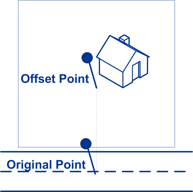 Street coordinates are accurate to 1/10,000 of a degree and interpolated points are accurate to the millionths of a degree. |
|
OffsetFromCorner |
Specifies the distance to offset the street end points in street-level matching. The distance is specified in the units you specify in the OffsetUnits option.This value is used to prevent addresses at street corners from being given the same geocode as the intersection. Note: Offset is not supported
for the United Kingdom (GBR) or Japan (JPN).
The default value varies by country:
The following diagram compares the end points of a street to offset end points. 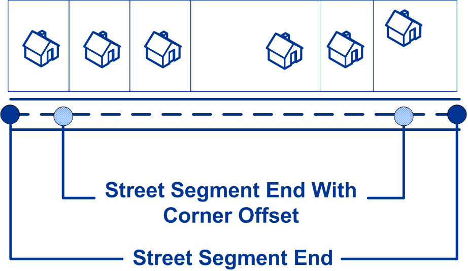
|
|
OffsetUnits |
Specifies the unit of measurement for the street offset and corner offset options. One of the following:
The default is Meters. |
|
CoordinateSystem |
A coordinate system is a reference system for the unique location of a point in space. Cartesian (planar) and Geodetic (geographical) coordinates are examples of reference systems based on Euclidean geometry. Spectrum™ Technology Platform supports systems recognized by the European Petroleum Survey Group (EPSG). Each country supports different coordinate systems. Depending on the country, you have one or more of the following options:
|
|
IncludeInputs |
Specifies whether to return the formatted input street address
and each input address element in a separate field. This feature can
help you understand how the input address was parsed and identify
specific input elements that could not be geocoded. For example, a
returned HouseNumber.Input could contain an invalid house number in
your input address. You can specify parsed input returns for a
specific country. For example, a REST API example for Canada
is:
Note: Data vintage must be 2014 Q4 or newer to get Parsed Address
Input returns. Also note that Parsed Address Input elements are
not returned for every country.
Parsed Address Input elements are returned in separately
labeled fields names with a .Input extension. For example:
|