Additional User Dictionary considerations
See the following topics for more information when working with User Dictionaries.
Data Access License
You must still have a valid access license to the data contained in the GSD when you are geocoding against your User Dictionary. For example, if you create a dictionary of New York streets and addresses, you must purchase the New York or entire U.S. GSD.
Use without GSD data files
- ctyst.dir—The USPS City-State table
- parse.dir—Address elements and abbreviations dictionary
- finmbr.dat—Spatial query file
- us.z9—Postal centroid information
- cbsac.dir—Required only if county names or CBSA/CSA data are needed
CASS standards
You cannot geocode to CASS standards using a User Dictionary. This also means that the ParcelPrecision Dictionary cannot be used during CASS geocoding.
Address Range order
- If the end is greater than the start, the range is ascending.
- If the start is greater than the end, the range is descending.
- If the start is equal to the end, the range is ascending.
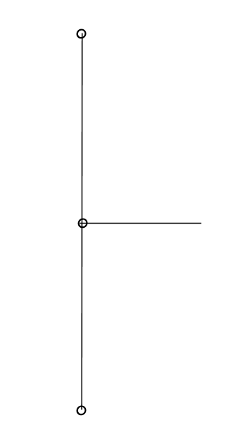
Street intersections and User Dictionaries
When geocoding to street intersections with a User Dictionary, the US geocoder cannot recognize the intersections if one or more of the segments that make up the intersection does not have an end point at the intersection. This can happen when you create the User Dictionary from a customized street table in which some segments that terminate at intersections do not have end points.
The figure below shows an intersection in a User Dictionary that does not have end points for all segments; this will not be recognized by the US geocoder as an intersection.
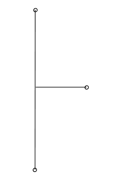
The figure below shows an intersection in a TIGER-based GSD which includes end points for all segments. The US geocoder geocodes to this intersection.