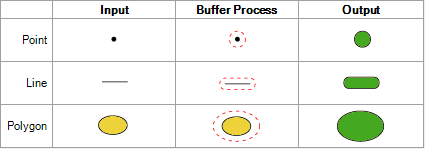
Buffer
Returns a geometry object which represents a buffered distance around a geometry object.
| Option Name | Description |
|---|---|
| Distance Units | Specifies the unit of measurement to use to calculate the buffer. One of the following:
|
| Buffer width | The distance from the source geometry to the buffer edge, in the units specified in the Distance units field. This controls the size of the buffer. |
| Smoothness | The minimum number of segments to use in creating a circle from buffering a point. The default is 12. |
| Geometry field | The input field that contains the geometry to buffer. This field also accepts geometries that are generated by stages in the Enterprise Routing Module, such as a LineString or Polygon. |
| Buffer width field | (Optional) If there is an input field that contains a buffer size to use to override
the default buffer width setting, specify the field here. Using an input
buffer width field allows you to set buffer width on a record-by-record
basis. This field supports string, double, float, integer, long, and BigDecimal as input data types. BigDecimal values are converted to double data types. |
| Geometry field | The output field that you want to contain the geometry returned by Spatial Calculator. |