Travel
Travel options specify assumptions to make about travel speed off network roads and whether to use only major roads when calculating the travel boundary. Most travel options have to do with ambient speed.
|
Parameter |
Description |
|---|---|
|
MaximumOffRoadDistance |
Specifies the maximum distance to allow travel off the road network. Examples of off-network roads include driveways and access roads. For example, if you specify a maximum off road distance of 1 mile the travel boundary will extend no further than one mile from the network road. If you specify a value of 0 the travel boundary will not extend beyond the road itself. Use the ambient speed options to specify the speed of travel along non-network roads. |
|
Units |
The units of measure in which you want the data returned. One of the following:
|
|
MajorRoads |
Specifies whether to include all roads in the calculation or just major roads. By default, the Get Travel Boundary is calculated with major roads set to true. This improves performance but the accuracy may decrease. This map represents a travel boundary with travel allowed on all roads: 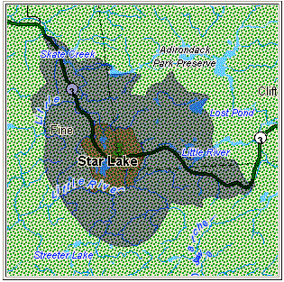 This map represents a travel boundary with travel restricted to major roads only: 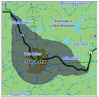 One of the following:
|
|
DefaultAmbientSpeed |
Specifies the speed to travel when going off a network road to find the travel boundary. Examples of off-network travel include driveways and access roads. This option is available only when you specify a time value in the DefaultCostUnits option or the TravelBoundaryCostUnits field. The default is 15. Specify the speed units in the AmbientSpeedUnit option. To control how off-network travel is used in the travel boundary calculation, you need to specify the speed of travel off the road network (the ambient speed). Ambient speed can affect the size and shape of the travel boundary polygon. In general, the faster the ambient speed, the larger the polygon. For example, if you were at a point with 5 minutes left, and if the ambient speed were 15 miles per hour, boundary points would be put at a distance of 1.25 miles. If the ambient speed were reduced to 10 miles per hour, boundary points would be put at a distance of 0.83 miles. Note that you can limit the distance allowed off a network road by using the MaximumOffRoadDistance option. Note: If you are calculating pedestrian travel boundaries we recommend that you change the default ambient speed to 3 MPH (5 KPH).
|
|
AmbientSpeedUnit |
The unit of measure to use with the value specified in the DefaultAmbientSpeed option.
|
|
AmbientSpeed.RoadType.<Type> |
Specifies the ambient speed to use for off-network travel based on the road type. If you do not specify an ambient speed for a road type, the default ambient speed will be used, as specified in the DefaultAmbientSpeed option. The following map shows an example of a travel boundary without ambient speed overrides: 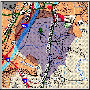 For comparison, this map shows the same travel boundary with ambient speed overrides: 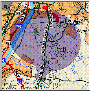 <Type> can be one of the following:
|