Options
|
Option |
Description |
|---|---|
|
Named table |
The name of the named table that contains the points of interest you want to find. For example, if you want to find the nearest grocery store, the spatial data would contain the coordinates of all grocery stores. |
|
Routing database |
The name of the database that contains the routing data to use to determine the shortest or fastest route. Use the database name specified in the Management Console's Database Resources tool. For more information, see Adding a Routing Database Resource. |
|
Search criteria |
Specifies how you want to identify the nearest point of interest. One of the following:
In some cases the point of interest that is the shortest driving distance may be different from the point that has the shortest travel time. This could occur if, for example, there is a highway to the further point but only a surface road to the closer point. The highway could result in faster travel speed and therefore a shorter travel time despite the longer distance. Likewise, the point of interest that is the shortest linear distance may not be the same as the point within the shortest driving distance. In the following illustration, note that the point that the closest linear distance is different from the point that is the closest travel distance since there is a lake that must be driven around in order to reach the point that is the closest linear distance. 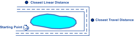
Note: Selecting "Fastest" or "Shortest" in this field will
result in an output field called
Time, which reports the time it takes
to get from the input point to the point of interest.
|
|
Coordinate system |
The coordinate system of the input coordinates. To change the default coordinate system, clear the default value then start typing the name of a coordinate system or an EPSG code to see a drop-down list of systems that begin with or contain those characters (the list appears after you have entered three alphanumeric characters). You can also click the browse button to open the Select Coordinate System dialog and select one from the list. Regardless of which coordinate system you select, the descriptive name will appear in the field and the respective EPSG code is saved for the stage. For more information on EPSG codes, see www.spatialreference.org. To retrieve a
list of supported codespaces for EPSG, you can submit the SOAP request
List Supported CoordSys by Code Space from the Geometry Service
Demo page at |
|
Coordinate format |
Specifies the format of latitude/longitude coordinates in the input. Note: Use this option only if you specify a Latitude/Longitude coordinate system. If the coordinate system is not a Latitude/Longitude coordinate system, set the coordinate format to Decimal.
One of the following:
|
|
Distance units |
Specifies how distance values are returned. One of the following:
|
|
Maximum distance |
The default radius of the search area in which to look for nearby points of interest. You can override this default value on a record-by-record basis by specifying the MaxDistance input field. Specify the radius in the units selected in the Distance units option. For example, to look for points of interest within a 10 mile radius, specify "10" in this field and select "Miles" in the Distance units option. The default is 0. |
|
Time units |
Specifies how time values are returned. One of the following:
|
|
Maximum candidates |
Specifies the maximum number of points of interest to return. If you specify "1" only the nearest point of interest is returned. If you specify "2" the two nearest points of interest are returned, and so forth. The default is 1. |
|
Return point-of-interest geometry |
Specifies whether to return the geometry of the point of interest. The point-of-interest geometry could be a point (such as a store location), line (such as a road segment), or polygon (such as a national park). The type of geometry returned depends on the data contained in the named table. |