Geocoding Options
GeocodeUSAddress Geocoding Options
The following table lists the options that control how a location's coordinates are determined.
| optionName | Description |
|---|---|
|
Dataset |
The name of the database resource that contains the data to use in the search process. Use the database name specified in Management Console's Spectrum Databases page. |
|
Offset |
Specifies the offset distance from the street segments, in feet. The range is 0 to 5280. Default = 50 feet. The offset distance is used in street-level geocoding to prevent the geocode from being in the middle of a street. It compensates for the fact that street-level geocoding returns a latitude and longitude point in the center of the street where the address is located. Since the building represented by an address is not on the street itself, you do not want the geocode for an address to be a point on the street. Instead, you want the geocode to represent the location of the building which sits next to the street. For example, an offset of 40 feet means that the geocode will represent a point 40 feet back from the center of the street. The distance is calculated perpendicular to the portion of the street segment for the address. Offset is also used to prevent addresses across the street from each other from being given the same point. The diagram below shows an offset point in relation to the original point. 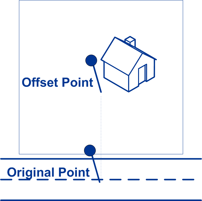 Street coordinates are accurate to 10,000ths of a degree and interpolated points are accurate to the millionths of a degree. |
|
Squeeze |
Specifies the distance, in feet, to move the street segment end points toward the middle of the segment. Squeeze is used in street-level matching. Use the squeeze setting to prevent address points from residing in an intersection or too close to the end of a street. The range is 0 to 2147483647. Default = 50 feet. The following diagram compares the end points of a street to squeezed end points. 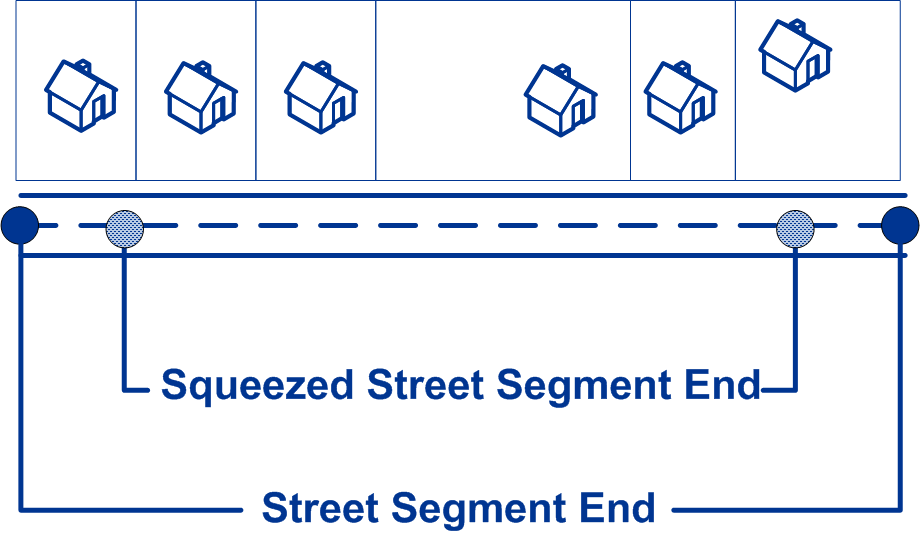
Squeezing the street segment endpoints affects street-level matching by reducing the length of a street segment, thereby reducing the spacing between address points along the segment. For example, if the length of a street segment is 1,000 feet and there are 10 addresses along the segent, street-level matching would result in each address being spaced 100 feet apart (1,000 ÷ 10). If you were to set a squeeze value of 100 feet, moving each street segment endpoint 100 feet torward the center of the street segment, the length of the street segment would be reduced to 800 feet (reduced by 100 feet on each end). Street-level matching would then result in addresses beging spaced 80 feet apart (800 ÷ 10). |
|
LatLonFormat |
Specifies the format of the latitude/longitude returned by the geocoder.
|
|
Datum |
Determines the North American Datum to use when geocoding datum on the input value. Datum is the mathematical model of the Earth used to calculate the coordinates on any map, chart, or survey system.
|
|
CentroidPreference |
Determines the type of centroids returned by the geocoder. A centroid is the center of an area. The centroid coordinates are the average of the sets of coordinates that describe the area.
|
|
FallbackToStreet |
Specifies whether to attempt to return a street centroid when an address-level geocode cannot be determined. To determine a street centroid, the geocoder searches the input ZIP Code or city for the closest match. If the geocoder is able to locate the street, it returns a geocode along the matched street segment. For example, if the input address is 5000 Walnut Street, Boulder 80301, and there is no 5000 Walnut Street, the geocoder searches for the closest match to that address within the ZIP Code 80301. If there were no input ZIP Code, the geocoder would search for the closest match to the input address within Boulder. If the input address is Walnut Street, Boulder 80301, since there is no house number, the geocoder searches for the street within the input ZIP Code. Street centroid geocodes are indicated by value in the LocationCode output field that begins with "C". For more information, see Street Centroid Location Codes. Note: This option is not available if you
set MatchMode to CASS.
|
|
FallbackToGeographic |
Specifies whether to attempt to return a city, county, or state centroid when an address-level geocode cannot be determined. The geocoder returns the most precise geographic centroid that it can based on the input. For example, if the input contains a valid city and state, a city centroid would be returned. Note: There are approximately 300 major cities that can be geocoded
to a city centroid level even if a valid state is not provided
in the input.
Geographic centroid geocodes are indicated by value in the LocationCode output field that begins with "G". For more information, see Geographic Centroid Location Codes. Note: This option is not available if you
set MatchMode to CASS.
|
|
AddressPointInterpolation |
Specifies whether to perform address point interpolation when an exact match for the address cannot be found in the geocoding database. Address point interpolation is a patented process that results in a more accurate interpolated point. It improves upon regular street segment interpolation by using point data in the interpolation process, as opposed to using street segments alone. Note: Address point interpolation is only
available when using a point-level geocoding database. It is not
available when using point addresses in an auxiliary
file.
The following illustration shows how address point interpolation works. In the example, the input house number is 71. The geocoding database contains address points for 67 and 77. The street segment has a range of 11 to 501. With address point interpolation, GeocodeUSAddress performs the interpolation for the input house number 71 using the points of 67 and 77. Without address point interpolation, GeocodeUSAddress performs the interpolation with the street segment end points of 11 and 501, resulting in a far less accurate result. 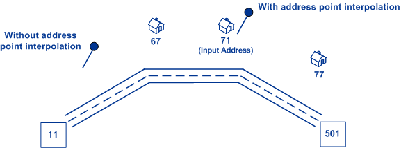 |
|
CenterlineOffset |
The offset distance, in feet, used to calculate the street centerline coordinates. Default = 0 feet. If you specify a value other than 0, GeocodeUSAddress calculates the street centerline coordinates by offsetting the centerline point by the distance you specify in the direction of the parcel centroid. 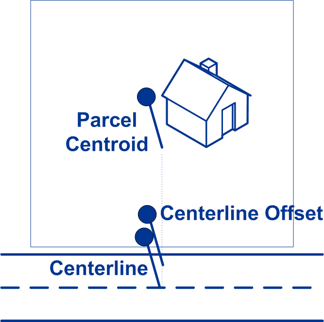 In an interpolated match, the centerline offset cannot be greater than the distance from the centerline to the interpolated address point. If you specify a centerline offset distance that is greater than this distance, the offset will be limited to the distance to the interpolated point. In effect, the centerline coordinates would be the same as the coordinates for the interpolated point. |
|
RetrieveAPN |
Specifies whether to determine the address's APN (assessor's parcel number). The APN is an ID number assigned to a property by the local property tax authority. The APN is returned in the APN output field, which is part of the Census output group. Note: This option requires that you have licensed and installed the
Cenrus Enhanced Points or Centrus Premium Points database. APN
data is not available for all addresses. See the coverage map
included with the points database.
|
|
RetrieveElevation |
Specifies whether to return the elevation of the address. Elevation is the distance above or below sea level of a given location. The elevation is returned in the Elevation output field, which is part of the Latitude/Longitude output group. Note: This option requires that you have licensed and installed the
Centrus Premium Points database. Elevation data is not available
for all addresses. See the coverage map included with the points
database.
|
|
AlwaysFindCandidates |
Specifies whether to enable centerline matching in order to get street centerline information. Note: Centerline matching requires that a point-level database is
installed.
|
|
FIND_APPROXIMATE_PBKEY |
When FIND_APPROXIMATE_PBKEY is enabled, if an address match is not made to Master Location Data (MLD), but to a different dataset, the PreciselyID of the nearest MLD point located within the search distance is returned. To distinguish when a fallback PreciselyID is returned, the PreciselyID return value contains a leading character of "X" rather than "P", for example: X00001XSF1IF. Note, all of the other fields returned for the address match, including the geocode and all associated data, reflect the match results for the input address. The fallback PreciselyID can then be used for the lookup to the GeoEnrichment dataset(s), and the attribute data for the fallback location is returned for the match. For more information, see PreciselyID Fallback. Note: This option requires that you have licensed and installed the
Master Location Dataset.
The search distance for the nearest MLD point is configurable using the SearchDistance parameter with an allowable search radius of 0-5280 feet and a default value of 150 feet.
|
|
SearchDistance |
When the PBKey Fallback option is enabled, this field sets the distance
to use when searching for the nearest address record with an
associated PreciselyID. The allowable
range is 0-5280 feet. Default = 150 feet.
Note: Supported only in
forward geocoding. |