Configuration Options
Reverse Geocode US Location Configuration Options
| Option | Description |
|---|---|
| Address Searching | |
|
Search distance |
Specifies the radius, in feet, that Reverse Geocode US Location searches for matches. The allowable range is 0 - 5280 feet. Default = 150 feet. |
|
Nearest point level address |
Enables matching to the nearest point address within the search radius, rather than to the closest feature - such as a street segment or intersection as well as point addresses. Default = disabled. Note: This option requires that at least one streets data set and
one points data set are loaded; otherwise, the match will be
made to the closest feature.
|
|
Nearest interpolated address |
Specifies whether Reverse Geocode US Location should find the nearest interpolated address to the input geocode. Default = enabled. Note: You can use this option with the Nearest
Intersection option to geocode to both
addresses and intersections.
|
|
Nearest unranged |
Specifies whether Reverse Geocode US Location can match to a street segment that does not have a number range. Default = enabled. Note: If you are using the point-level data option, Reverse Geocode US Location ignores the
Nearest Unranged option.
|
|
Nearest intersection |
Specifies whether Reverse Geocode US Location should find the nearest street intersection to the input geocode. Default = enabled. Note: You can use this option with the Nearest address
option to geocode to both addresses and intersections.
|
| Geocoding | |
|
Offset |
Specifies the offset distance from the street segments. The allowable range is 0 - 5280 feet. Default = 50 feet. The offset distance is used in street-level geocoding to prevent the geocode from being in the middle of a street. It compensates for the fact that street-level geocoding returns a latitude and longitude point in the center of the street where the address is located. Since the building represented by an address is not on the street itself, you do not want the geocode for an address to be a point on the street. Instead, you want the geocode to represent the location of the building which sits next to the street. For example, an offset of 40 feet means that the geocode will represent a point 40 feet back from the center of the street. The distance is calculated perpendicular to the portion of the street segment for the address. Offset is also used to prevent addresses across the street from each other from being given the same point. The diagram below shows an offset point in relation to the original point. 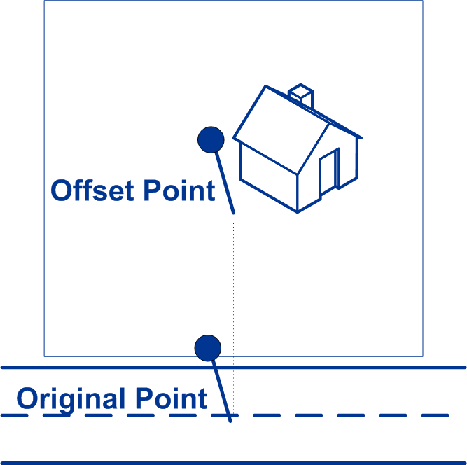
Street coordinates are accurate to 1/10,000th of a degree and interpolated points are accurate to 1/1,000,000th of a degree. |
|
Squeeze |
Specifies the distance, in feet, to squeeze the street end points in street-level geocoding. The range is 0 -2147483647 feet. Default = 50 feet. The following diagram compares the end points of a street to squeezed end points. 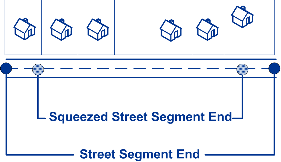
|
|
Output latitude and longitude format |
Specifies the format to use for returned latitude/longitude.
|
|
Input latitude and longitude format |
Specifies the format to use for input latitude/longitude.
|
|
Determine elevation |
Specifies whether Reverse Geocode US Location returns the elevation of the address. Elevation is the distance above or below sea level of a given location. The elevation is returned in the Elevation output field, which is part of the Latitude/Longitude output group. Default = disabled. Note: This option requires that you have licensed and installed the
Centrus Premium Points database. Elevation data is not available
for all addresses. See the coverage map included with the points
database.
|
|
Determine Assessor's Parcel Number |
Specifies whether Reverse Geocode US Location should determine the address's APN (assessor's parcel number). The APN is an ID number assigned to a property by the local property tax authority. The APN is returned in the APN output field, which is part of the Census output group. Default = disabled. Note: This option requires that you have licensed and installed the
Cenrus Enhanced Points or Centrus Premium Points database. APN
data is not available for all addresses. See the coverage map
included with the points database.
|
|
Allow PBKey fallback |
When Allow PBKey fallback is enabled, if an address match is not made to Master Location Data (MLD), but to a different dataset, the PreciselyID of the nearest MLD point located within the search distance is returned. To distinguish when a fallback PreciselyID is returned, the PreciselyID return value contains a leading character of "X" rather than "P", for example: X00001XSF1IF. Note, all of the other fields returned for the address match, including the geocode and all associated data, reflect the match results for the input address. The fallback PreciselyID can then be used for the lookup to the GeoEnrichment dataset(s), and the attribute data for the fallback location is returned for the match. For more information, see PreciselyID Fallback. Note: This option requires that you have licensed and installed the
Master Location Dataset.
The search distance for the nearest MLD point is configurable using the Reverse Geocode US Location Search distance field. The allowable range is 0 - 5280 feet. Default = 150 feet. |