Geocoding Preferences
The preferences in the Geocoding category enable you to control how a location's coordinates are determined. The following sections cover the geocoding global defaults preferences, which are available for all countries, and the country-specific geocoding options, which apply to a subset of countries.
Global Defaults in Management Console
You can create overrides for some of the global default options on a per-country
basis. These options have a ![]() next to the Country column value. For more
information about how to create overrides, see Setting Country Overrides.
next to the Country column value. For more
information about how to create overrides, see Setting Country Overrides.
Global Defaults in Enterprise Designer
If you modify a global defaults option, then that selection is applied to all countries and cannot be changed on a per-country basis. Subsequently, if you select a country and view its options, the modified global defaults option will be inactive in the GUI.
| Preference | Description |
|---|---|
| Type of Geocode | There are different ways that an address can be geocoded. The
following lists the geocoding types from the most accurate to least
accurate. The support for these geocode types depends on the type of data available in your configured geocoding dataset(s). Refer to your country's section to locate geocoding level support information.
|
| Use Address Point Interpolation | Address point interpolation is a patented process that results in
a more accurate interpolated point. It improves upon regular street
segment interpolation by using point data in the interpolation
process, as opposed to using street segments alone. Default =
disabled. Note: Address point interpolation requires both a
street-level and a point-level geocoding dataset. Note: For
USA - This feature is not supported with point addresses in
Auxiliary files. The following illustration shows how address
point interpolation works. In the example, the input house number is
71. The geocoding database contains address points for 67 and 77.
The street segment has a range of 11 to 501. With address point
interpolation, the input house number 71 is interpolated using the
points of 67 and 77. Without address point interpolation, the
interpolation is performed with the street segment end points of 11
and 501, resulting in a far less accurate result. 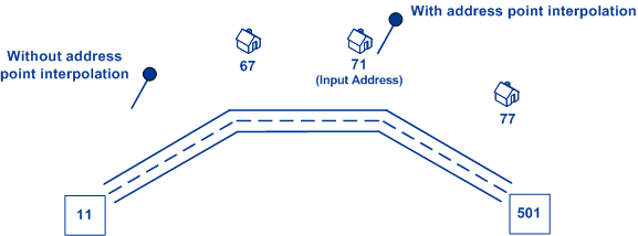
|
| Fallback to postal centroid | When an address-level geocode cannot be determined, attempt to
return a ZIP Code centroid. Default = enabled. Note: For USA - This
option is ignored if you set Match Mode to
CASS. |
| Fallback to geographic centroid | When an address-level geocode cannot be determined, attempt to return a centroid of a geographic area. The geocoder returns the most precise geographic centroid that it can based on the input. For example, if the input contains a valid city and state, a city centroid would be returned. Default = enabled. |
| Fallback to world geocoder | When an address-level geocode for a country-specific geocoder cannot be determined, the search falls back to World Places if world geocoding data is configured. Typically used for countries that do not have geocoders or if that country's data is not present. Default = disabled. |
| World Geocoder Only | Geocodes against World geocoder only. This is useful since you can only configure one database for GGM, add all of your data in GGM, then use this preference to run World data without having to configure it separately. This preference is available for forward geocoding only. |
| Point Positioning |
Street Offset Specifies the offset distance from the street segments to use in street-level geocoding. The offset distance is used in street-level geocoding to prevent the geocode from being in the middle of a street. It compensates for the fact that street-level geocoding returns a latitude and longitude point in the center of the street where the address is located. Since the building represented by an address is not on the street itself, you do not want the geocode for an address to be a point on the street. Instead, you want the geocode to represent the location of the building which sits next to the street.For example, an offset of 50 feet means that the geocode will represent a point 50 feet back from the center of the street. The distance is calculated perpendicular to the portion of the street segment for the address. Offset is also used to prevent addresses across the street from each other from being given the same point. Default value = 7 meters. The following diagram shows an offset point in relation to the original point. 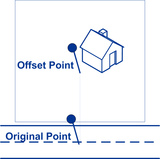 You can select either Feet or Meters for your unit of measurement. |
|
Corner Offset Specifies the distance to offset the street end points in street-level matching. This value is used to prevent addresses at street corners from being given the same geocode as the intersection. Defines the offset position of the geocoded point with respect to the corner. Default value = 7 meters.The following diagram compares the end points of a street to offset end points. 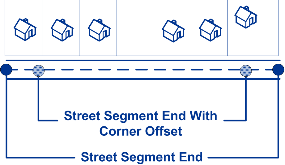 You can select either Feet or Meters for your unit of measurement. |