Point in Polygon Subflow
This procedure describes how to create a subflow using the Query Spatial Data stage to deterimine if a point is located within a given polygon.
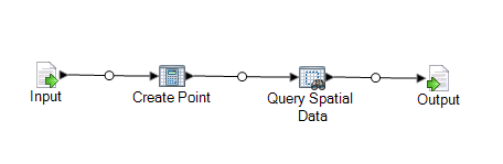
This subflow takes as the source an x and y and creates a point geometry using Spatial Calculator's Create Point operation. The resulting geometry is the input for the Query Spatial Data stage which is then output to an output sink.
To create a point in polygon subflow:
-
Double-click on the Output sink and check the field you wish to expose. In our
example, check the State field. Click OK.