| diagram |
 |
| namespace |
http://www.mapinfo.com/midev/service/featurecollection/v1 |
| type |
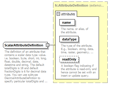
extension of fc:AttributeDefinition |
| properties |
| base | fc:AttributeDefinition |
|
| used by |
|
| attributes |
| Name | Type | Use | Default | Fixed | Annotation | | name | xsd:string | required | | | | documentation | | The name, or alias, of the attribute. |
| | dataType | fc:AttributeDataType | required | | | | documentation | | The type of the attribute. E.g., boolean, string, data, time, raster, geometry, etc. |
| | readOnly | xsd:boolean | | | | | documentation | | A boolean flag indicating if the attribute is read-only and hence cannot be set with an insert or update query. |
|
|
| annotation |
| documentation | | The definition of an attribute that contains a scalar data type value. i.e. boolean, byte, short, int, long, float, double, decimal, date, datetime and string. The default totalDigits is 18 and default fractionDigits is 6 for decimal data type. You can use subtype DecimalAttributeDefinition to specify particular totalDigits and fractionDigits for decimal data type. |
|