Geocode POST Request
The POST request enables you to submit a single input address or a list of addresses for batch processing. Matching and/or geocoding preferences can optionally be specified to the Geocode service and receive the associated latitude/longitude coordinates and location information. The preference options for a POST request are the complete set of available options.
Base URI
http://<server>:<port>/<context>/rest/GeocodeService/<name_of_service>See Example: JSON POST Request & Response.
http://<server>:<port>/rest/GlobalGeocode/geocode[.content type]Request Parameters
- addresses - The address or addresses to be geocoded. The addresses array of Address objects. The addresses array may contain one or more input addresses. Required.
- type - The type of geocode. Optional. The type parameter is optional.
- preferences - The matching and geocoding options. Optional.
- mustMatchMode - The match criteria for determining match candidates Optional.
- returnFieldsDescriptor - Controls the return of additional data on a candidate. Optional.
| Parameter | Type | Description |
|---|---|---|
POST: type GET: geocodeType |
String |
Indicates the geocode type to be performed. Optional.
|
POST: returnAllCandidateInfo |
Boolean | Specifies whether to return all available information for each candidate.
|
POST: fallbackToGeographic GET: fallbackGeo |
Boolean | Specifies whether to attempt to determine a geographic region
centroid when an address-level geocode cannot be determined. Optional.
|
POST: fallbackToPostal GET: fallbackPostal |
Boolean | Specifies whether to attempt to determine a post code centroid
when an address-level geocode cannot be determined. Optional.
|
POST: maxReturnedCandidates GET: maxCands |
Integer | The maximum number of candidates to return. Optional. Must be an integer value. Default = 1. |
| streetOffset | Double | The offset distance from the street segments. The distance is in the units you
specify in the streetOffsetUnits preference. Default value = 7
meters. The offset distance is used in street-level geocoding to prevent the geocode from being in the middle of a street. It compensates for the fact that street-level geocoding returns a latitude and longitude point in the center of the street where the address is located. For example, an offset of 50 feet means that the geocode will represent a point 50 feet back from the center of the street. The distance is calculated perpendicular to the portion of the street segment for the address. Offset is also used to prevent addresses across the street from each other from being given the same point.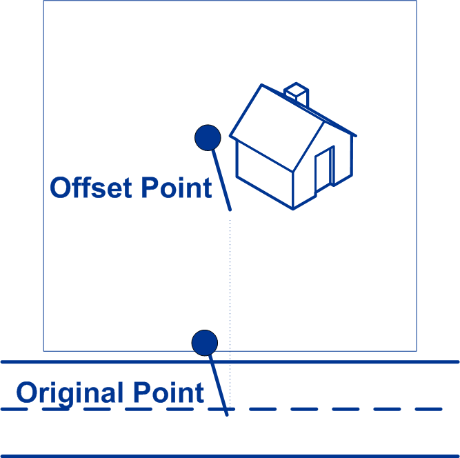 |
| streetOffsetUnits | String | Unit of measurement for the street offset. One of the following: Feet, Meters (default). |
| cornerOffset | Double | Distance to offset the street end points in street-level matching. The distance
is in the units you specify in the cornerOffsetUnits
preference. This value is used to prevent addresses at street corners from being
given the same geocode as the intersection. Defines the offset position of the
geocoded point with respect to the corner. Default value = 7 meters. The following diagram compares the end points of a street to offset end points. 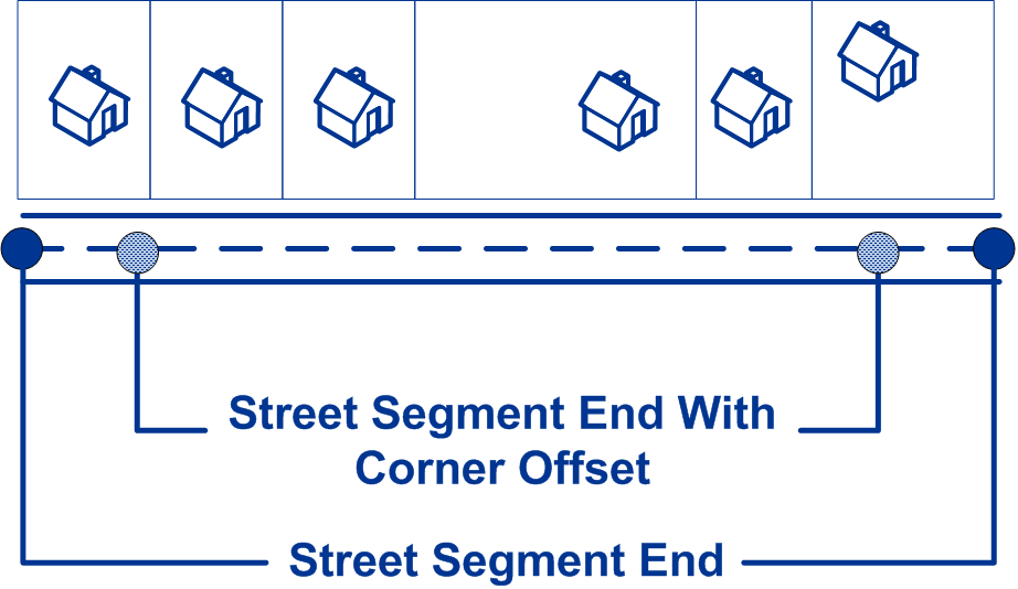 |
| cornerOffsetUnits | String | Unit of measurement for the street offset. One of the following: Feet, Meters (default). |
| matchMode | String | Match modes determine the leniency used to make a match between the input
address and the reference data. Select a match mode based on the quality of your
input and your desired output. The following match modes are available:
|
| maxRanges | Integer | A range is a series of addresses along a street segment. For example, 5400-5499
Main St. is an address range representing addresses in the 5400 block of Main St. A
range may represent just odd or even addresses within a segment, or both odd and
even addresses. A range may also represent a single building with multiple units,
such as an apartment building. This option specifies the maximum number of ranges to return for each candidate. Since the geocoder returns one candidate per segment, and since a segment may contain multiple ranges, this option allows you to see the other ranges in a candidate's segment. Must be an integer value. Default = 0. |
| maxRangeUnits | Integer | This option specifies the maximum number of units (for
example, apartments or suites) to return for each range. For example, if you were to geocode an office building at 65 Main St. containing four suites, there would be a maximum of four units returned for the building's range: 65 Suite 1, 65 Suite 2, 65 Suite 3, and 65 Suite 4. If you were to specify a maximum number of units as 2, then only two units would be returned instead of all four. Must be an integer value. Default = 0. |
POST: clientCoordSysName |
String | Specifies the coordinate system that you want to convert the
geometry to. The format must be the European Petroleum Survey Group (EPSG) code or
the SRID code. Default = EPSG:4326. Specify the
coordinate reference system in the format
|
POST: matchOnAddressNumber |
Boolean |
|
POST: matchOnPostCode1 |
Boolean |
|
|
POST: matchOnPostCode2 |
Boolean |
|
POST: matchOnAreaName1 |
Boolean |
|
POST: matchOnAreaName2 |
Boolean |
Note: This option is not supported by USA.
|
POST: matchOnAreaName3 |
Boolean |
|
POST: matchOnAreaName4 |
Boolean |
|
POST: matchOnAllStreetFields |
Boolean |
|
POST: returnAllCustomFields |
Boolean |
|
POST: returnedCustomFieldKeys |
List<String> | Specifies a list of keys that represent the custom fields to be returned in the
candidate's customFields output. To specify multiple key/value
pairs for a country, use spaces to separate the names of the custom fields to be
returned. Custom fields vary by country. For example: “CTYST_KEY”
or “DATATYPE”. Default: empty. |
POST: returnMatchDescriptor |
Boolean |
|
POST: returnStreetAddressFields |
Boolean |
|
POST: returnUnitInformation |
Boolean |
|