Reverse Geocode POST Request
The POST request enables you to submit a single input coordinate or a list of coordinates for batch processing. A country code, coordinate reference system and matching preferences can optionally be specified. A response containing a list of candidates with associated address data and matching information is returned. The preference options for a POST request are the complete set of available options.
Base URI
http://<server>:<port>/<contextpath>/rest/GeocodeService/reverseGeocode
[.content type]http://<server>:<port>/rest/GlobalGeocode/reverseGeocode[.content type]where:
- json
- Default content type is JSON, unless superseded by HTTP content negotiation
- xml
- Default content type is XML, unless superseded by HTTP content negotiation
Request Parameters
- points — The input coordinates or multiple input coordinates to be reverse geocoded. Required.
- preferences — The matching options. Optional.
| Name | Type | Description |
|---|---|---|
| points an array object containing both a geometry object and a country code string: | ||
| country | String | Indicates the country to search for the reverse geocode result, specified using a 3-letter ISO country code. Optional. For country codes, see ISO 3166-1 Country Codes. |
| geometry object, consisting of the following elements: | ||
| coordinates | Double | Specifies the x, y input coordinates, where x=longitude and y=latitude. For example: [ -105.25175, 40.024494 ] |
| type | String | Indicates the type of geographic entity the input coordinates represent.
|
| crs | String | Indicates the coordinate reference system used for the input coordinates. The
format must be the European Petroleum Survey Group (EPSG) code or the SRID code.
Default = EPSG:4326. Specify the coordinate
reference system in the format codespace:code. |
| preferences object, consisting of
the following elements. Note: Only the following elements in the
preferences object are applicable to the Reverse Geocode
service. Note: To override the default value of a
preferences element for a specific country, specify the
key/value pair in the customPreferences object, with the key
constant preceded by the ISO-3166 3-character country code plus period. For
example: DEU.streetOffset. |
||
| distance | Double | Sets the radius in which the Reverse Geocode service searches for a match to the input coordinates. The unit of measurement is specified using distanceUnits. Default = 150 meters. Maximum value = 5280 feet (1 mile ) or 1609 meters. |
| distanceUnits | String | Specifies the unit of measurement for the search distance. One of the
following:
|
| clientLocale | String | This field is used for a country that has multiple languages to determine the
preferred order of language candidates. The locale must be specified in the format
"cc_CC", where "cc" is the language and "CC" is the ISO 3166-1 Alpha-2 code, such
as: en-US, fr_CA or fr_FR. For example, Egypt supports both english and arabic. The clientLocale field could be set to either english-first (en-EN) or arabic-first (ar-EG). Note: For a listing of ISO Alpha-2 country codes, see
ISO 3166-1 Country Codes. |
POST: clientCoordSysName |
String | Specifies the coordinate system that you want to convert the
geometry to. The format must be the European Petroleum Survey Group (EPSG) code or
the SRID code. Default = EPSG:4326. Specify the
coordinate reference system in the format
|
| streetOffset | Double | The offset distance from the street segments. The distance is in the units you
specify in the streetOffsetUnits preference. Default value = 7
meters. The offset distance is used in street-level geocoding to prevent the geocode from being in the middle of a street. It compensates for the fact that street-level geocoding returns a latitude and longitude point in the center of the street where the address is located. For example, an offset of 50 feet means that the geocode will represent a point 50 feet back from the center of the street. The distance is calculated perpendicular to the portion of the street segment for the address. Offset is also used to prevent addresses across the street from each other from being given the same point.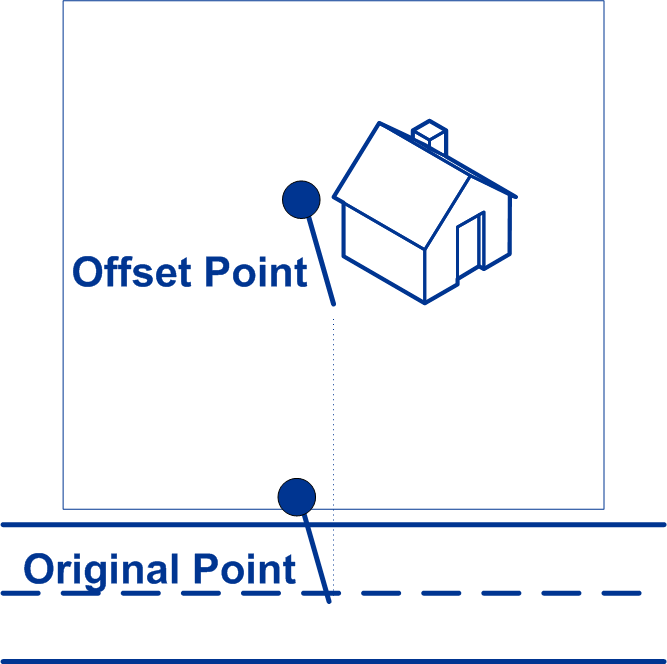 |
| streetOffsetUnits | String | Unit of measurement for the street offset. One of the following: Feet, Meters (default). |
| cornerOffset | Double | Distance to offset the street end points in street-level matching. The distance
is in the units you specify in the cornerOffsetUnits
preference. This value is used to prevent addresses at street corners from being
given the same geocode as the intersection. Defines the offset position of the
geocoded point with respect to the corner. Default value = 7 meters. The following diagram compares the end points of a street to offset end points. 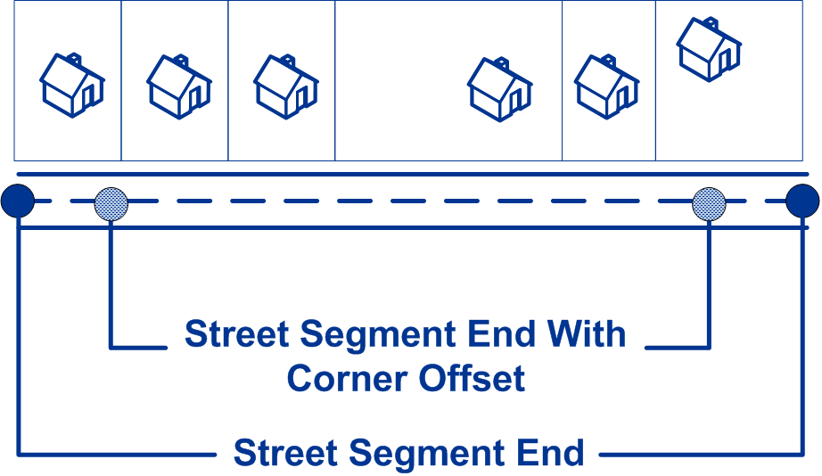 |
| cornerOffsetUnits | String | Unit of measurement for the street offset. One of the following: Feet, Meters (default). |
| customPreferences | Map<String key, String value> | Specifies the country-specific input preferences. This object can be used to
specify:
To override the default value for a specific country, precede the key constant with the ISO-3
country code plus period, and then specify the value. For example, in an XML
request, an entry for a country override would look as follows:
Custom
country input options are available for the following countries:
|