
Geotest
Geotest is a sample program that demonstrates the functionality of GeoStan. Geotest is located in the 64bit Windows or samples (UNIX) directory. The sample code is located in the samples (UNIX) or Ms_c (Windows) directory.
You can run Geotest without any arguments using the test.ini file or in interactive mode with arguments on the command line.
Configuring Geotest
If you do not specify any arguments on the command line when initializing geotest, geotest initializes using the information in the test.ini file. You need to modify the test.ini file to fit the configuration of your system. You can find this file in the directory where you installed GeoStan in Test_fls.
The format of the test.ini file consists of the following lines:
Line 1 Search path for the GeoStan data files.
Line 2 Search path and file name for the ZIP + 4 file (Us.z9).
Line 3 Search path and file name for GeoStan license file (Geostan.lic).
Line 4 Password for your GeoStan license.
Line 5 (Optional) DPV data directory.
Line 6 (Optional) Security key to initialize DPV functionality.
Line 7 (Optional) LACSLink data directory.
Line 8 (Optional) Security key to initialize LACSLink functionality.
Line 9 (Optional) Amount of memory GeoStan uses for memory mapped files. For more information, see GS_INIT_FILE_MEMORY_LIMIT.
Line 10 (Optional) Sets a select number of processing options.
n A – Loads the files for address geocoding.
n Z – Loads the file for centroid geocoding.
n S – Loads spatial query files.
n C – Loads the file (zipsmld.gsd) for returning PreciselyIDs for Master Location Data addresses with ZIP centroid locations.
Line 11 (Optional) SuiteLink data directory.
Line 12 (Optional) To exit the main menu, enter q or Q.
Line 13 (Optional) Sets the cache size (0, 1, or 3).
Line 14 (Optional) Sets the path to a file that contains all of your find properties.
Line 15 (Optional) RDI data directory.
For example:
C:\geostan\datasetsC:\geostan\datasets\us.z9C:\licensefiles\geostan.lic43218765C:\geostan\datasets\DPV9999-9999-9999-9999C:\geostan\datasets\LACS9999-9999-9999-9999Using Geotest
You can run geotest using geotest.exe located in the platform-specific file where you installed GeoStan, or you can run geotest by specifying arguments on a command line.
Command Line
Command line usage format:
geotest searchPath ZIP4File licenseFile password (-sp searchpath -z ZIP4File -l licenseFile -lpw password) [-dp DPVDataDir -dk DPVSecurityKey] [-lp LACSLinkDataDir -lk LACSLinkSecurityKey] [-tp SuiteLinkDataDir] [-rp RDIDataDir][-gc] [-fml fileMemoryLimit] [-q][-i initProps] [-c cacheSize] [-fp findPropsPath]where:
|
searchPath (-sp) |
One or more GeoStan path names. |
|
ZIP4File (-z) |
The fully-qualified path to the us.z9 file. |
|
licenseFile (-l) |
The name of the GeoStan license file. |
|
password (-lpw) |
The password to the GeoStan license file. |
|
DPVDataDir (-dp) |
The name of the directory containing DPV data. |
|
DPVSecurityKey (-dk) |
The security key for the DPV product authorization. |
|
LACSLinkDataDir (-lp) |
The name of the directory containing LACSLink data. |
|
LACSLinkSecurityKey (-lk) |
The security key for the LACSLink product authorization. |
|
fileMemoryLimit (-fml) |
The memory size for GS_INIT_FILE_MEMORY_LIMIT. |
|
cacheSize (-c) |
The size of the cache to use (0, 1, or 2) for GS_INIT_CACHESIZE. |
|
initProps (-i) |
One or more letters representing initialization properties: |
|
A - GS_INIT_OPTIONS_ADDR_CODE |
*.gsd or UD |
|
Z - GS_INIT_OPTIONS_Z9_CODE |
us.z9 |
|
S - GS_INIT_OPTIONS_SPATIAL_QUERY |
finmbr.dat |
|
C - GS_INIT_OPTIONS_ZIP_PBKEYS |
zipsmld.gsd |
|
SuiteLinkDataDir (-tp) |
The name of the directory containing SuiteLink data |
|
RDIDataDir (-rp) |
The name of the directory containing RDI data |
|
quitMainMenu |
A q or Q to indicate how to exit the Main menu |
|
findPropsPath (-fp) |
The fully-qualified path to a forward geocoding find properties file |
|
-gc |
An option to initialize Geotest with the same GsInit values as Geocoder. |
The following is an example of running geotest from the command line.
geotestsearchpath z9path licensefile password -dpdpvpath -dkdpvSecuritykey -lplacslinkpath -lklacslinksecuritykey -fml memorylimit-fp Find Properties Path -tp SuiteLink Path -rp RDI Path -gc geocoder init flags -c cache size -sp search path -z z9file -l license file -lpw license password -log turn on logging -q quit main menu -i Init optionsIf any of the setup criteria does not initialize correctly, a list of problems displays. Check and correct all of the listed problems and rerun geotest.
The Geotest Main Menu displays when all configurations are correct (sample menu shown below).
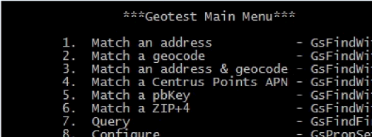
The following contains a description of each menu item.
Match an address Prompts for an address to standardize and geocode. Returns a matched address or a list of possible matches.
Match a geocode Prompts for a geocode (latitude and longitude) to convert to an address. Returns the closest match. Returns a possible match; the address may not physically exist or may not accept mail delivery.
Match an address & geocodePrompts for an input street address and latitude/longitude coordinates. Returns a matched address or a list of possible matches.
Match a PreciselyID Prompts for a PreciselyID unique identifier (PBKey) to attempt a Reverse PreciselyID Lookup match. For more information, see PreciselyID Fallback.
Match a ZIP + 4 Prompts for information to attempt a ZIP Code match.
Query Prompts for a ZIP Code or city and state, then asks if you want to search by street by name or soundex. If you want to output to a file, enter the file name at the Name prompt.
Configure Provides a way for you to configure the matching and output of geotest.
Z4Change Prompts for ZIP Code information, then indicates if the ZIP + 4 has changed since you last processed the address.
Generate Soundex Prompts for a string and returns a soundex value.
Test range Prompts for the house number and the low and high house number in the range to determine if the house number falls within a range.
Verify Aux File Prompts for the path of the auxiliary file to verify if any error exists in the file.
Acquire Metadata Provides information regarding the input data sets.
Geographic Geocoding Prompts for a city, a county, and a state to provide returns for CloseFlag, City\County\State, State, ResultCode, FIPS, LocationCode, Lat, and Long.
Query Cities Prompts for a city name, full or partial, or a ZIP Code, 3- or 5-digits. Returns the cities that match your input.
Get City MBR Prompts for a city number. Returns the Minimum Bounding Rectangle (MBR).
q or Q Quits the application.
Configure - User Settable Options window
To set matching and geocoding options for forward geocoding, enter the Configure option on the main menu, then select User Settable Options. Geotest displays the window below.
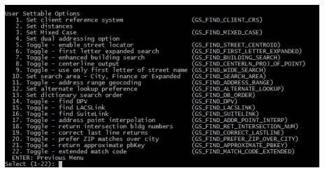
For more information about these options, see the associated section referenced by the links in the following table.
1. Set client reference system |
|
2. Set distances |
|
3. Set Mixed Case |
|
4. Set dual addressing option |
|
5. Toggle - enable street locator |
|
6. Toggle - first letter expanded search |
|
7. Toggle - enhanced building search |
|
8. Toggle - centerline output |
|
9. Toggle - use only first letter of street name |
|
10. Set search area - City, Finance or Expanded |
|
11. Toggle - address range geocoding |
|
12. Set alternate lookup preference |
|
13. Set dictionary search order |
|
14. Toggle - find DPV |
|
15. Toggle - find LACSLink |
|
16. Toggle - find SuiteLink |
|
17. Toggle - address point interpolation |
|
18. Toggle - return intersection bldg numbers |
|
19. Toggle - correct last line returns |
|
20. Toggle - prefer ZIP matches over city |
|
21. Toggle - return approximate PreciselyID |
|
22. Toggle - extended match code |