
Geocode Options
The options in the Geocode category enable you to control how a location's coordinates are determined. The following sections cover the Geocode global defaults options, which are available for all countries, and the country-specific Geocode options, which apply to a subset of countries.
Global Defaults
If you modify a global defaults option, then that selection is applied to all countries and cannot be changed on a per-country basis. Subsequently, if you select a country and view its options, the modified global defaults option will be inactive in the GUI.
| Option Name | Country Support | Description |
|---|---|---|
| Type of Geocode | All | There are different ways that an address can be geocoded. The
following lists the Geocode types from the most accurate to least
accurate. The support for these geocode types depends on the type of data available in your configured Geocode dataset(s). Refer to your country's section to locate Geocode level support information.
|
| Use Address Point Interpolation | All | Address point interpolation is a patented process that results in
a more accurate interpolated point. It improves upon regular street
segment interpolation by using point data in the interpolation
process, as opposed to using street segments alone. Default =
disabled. Note: Address point interpolation requires both a
street-level and a point-level Geocode dataset. The
following illustration shows how address point interpolation works.
In the example, the input house number is 71. The Geocode database
contains address points for 67 and 77. The street segment has a
range of 11 to 501. With address point interpolation, the input
house number 71 is interpolated using the points of 67 and 77.
Without address point interpolation, the interpolation is performed
with the street segment end points of 11 and 501, resulting in a far
less accurate result. 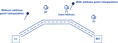 |
| Fallback to postal centroid | All | When an address-level geocode cannot be determined, attempt to
return a ZIP Code centroid. Default = enabled. Note: For USA - This
option is ignored if you set Match Mode
to CASS. |
| Fallback to geographic centroid | All | When an address-level geocode cannot be determined, attempt to return a centroid of a geographic area. The geocoder returns the most precise geographic centroid that it can based on the input. For example, if the input contains a valid city and state, a city centroid would be returned. Default = enabled. |
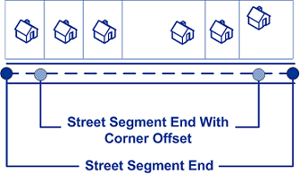
| Point Positioning | All |
|
| All |
|
Country-Specific Geocoding Options
| Option Name | Country Support | Description |
|---|---|---|
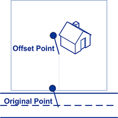
| Calculate Centerline Projection of Point |
CAN |
Computes the closest point on the street from
the parcel point. Default = disabled. Note: This feature requires
that a point-level Geocode dataset is installed. |
| Point Positioning |
CAN |
|
| ZIP Code Centroid Level | USA | A ZIP Code centroid match returns the center point of an area
defined by one of the following types of ZIP Codes:
|