| diagram |
|
||
| namespace | http://www.mapinfo.com/midev/service/featurecollection/v1 | ||
| properties |
|
||
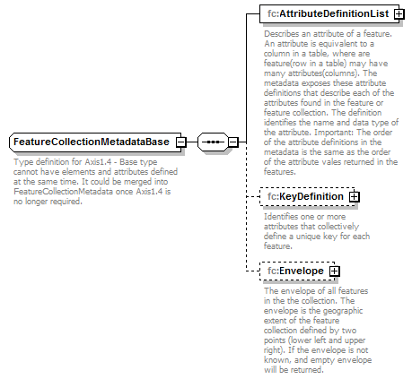
| children | fc:AttributeDefinitionList fc:KeyDefinition fc:Envelope | ||
| used by |
|
||
| description |
|
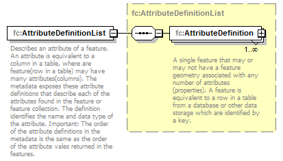
element FeatureCollectionMetadataBase/AttributeDefinitionList
| diagram |
|
||
| namespace | http://www.mapinfo.com/midev/service/featurecollection/v1 | ||
| type | fc:AttributeDefinitionList | ||
| properties |
|
||
| children | fc:AttributeDefinition | ||
| description |
|
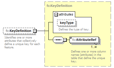
element FeatureCollectionMetadataBase/KeyDefinition
| diagram |
|
||||||||||||||
| namespace | http://www.mapinfo.com/midev/service/featurecollection/v1 | ||||||||||||||
| type | fc:KeyDefinition | ||||||||||||||
| properties |
|
||||||||||||||
| children | fc:AttributeRef | ||||||||||||||
| attributes |
|
||||||||||||||
| description |
|
element FeatureCollectionMetadataBase/Envelope
| diagram |
|
||||||||||||||
| namespace | http://www.mapinfo.com/midev/service/featurecollection/v1 | ||||||||||||||
| type | tns:Envelope | ||||||||||||||
| properties |
|
||||||||||||||
| children | tns:Pos | ||||||||||||||
| attributes |
|
||||||||||||||
| description |
|