|
diagram
|
|
|
namespace
|
http://www.mapinfo.com/midev/service/mapping/v1
|
|
type
|
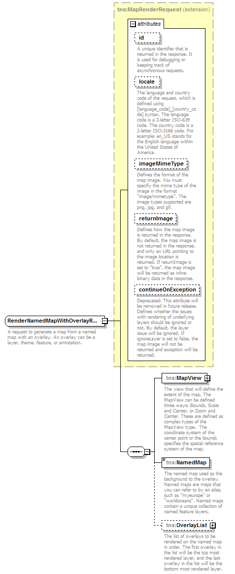
extension of
tns:MapRenderRequest
|
|
properties
|
|
base
|
tns:MapRenderRequest
|
|
|
children
|
tns:MapView
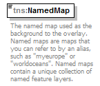
tns:NamedMap
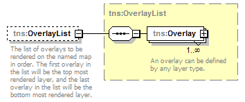
tns:OverlayList
|
|
used by
|
|
|
attributes
|
|
Name
|
Type
|
Use
|
Default
|
Fixed
|
Annotation
|
|
id
|
xsd:string
|
optional
|
|
|
|
|
A unique identifier that is returned in the response. It is used for debugging or keeping track of asynchronous requests.
|
|
|
locale
|
xsd:string
|
optional
|
|
|
|
|
The language and country code of the request, which is defined using [language_code]_[country_code] syntax. The language code is a 2-letter ISO-639 code. The country code is a 2-letter ISO-3166 code. For example: en_US stands for the English language within the United States of America.
|
|
|
imageMimeType
|
xsd:string
|
optional
|
image/png
|
|
|
|
Defines the format of the map image. You must specify the mime type of the image in the format "image/mimetype". The image types supported are png, jpg, and gif.
|
|
|
returnImage
|
xsd:boolean
|
optional
|
false
|
|
|
|
Defines how the map image is returned in the response. By default, the map image is not returned in the response, and only an URL pointing to the image location is returned. If returnImage is set to "true", the map image will be returned as inline binary data in the response.
|
|
|
continueOnException
|
xsd:boolean
|
optional
|
true
|
|
|
|
Deprecated: This attribute will be removed in future release. Defines whether the issues with rendering of underlying layers should be ignored or not. By default, the layer issue will be ignored. If ignoreLayer is set to false, the map image will not be returned and exception will be returned.
|
|
|
|
description
|
|
|
A request to generate a map from a named map with an overlay. An overlay can be a layer, theme, feature, or annotation.
|
|
|
diagram
|
|
|
namespace
|
http://www.mapinfo.com/midev/service/mapping/v1
|
|
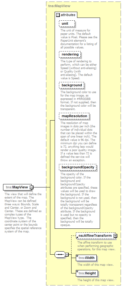
type
|
tns:MapView
|
|
properties
|
|
|
children
|
tns:AffineTransform
tns:Width
tns:Height
|
|
attributes
|
|
Name
|
Type
|
Use
|
Default
|
Fixed
|
Annotation
|
|
unit
|
tns:PaperUnit
|
optional
|
Pixel
|
|
|
|
The unit of measure for paper units. The default value is Pixel. Please see the PaperUnit element's documentation for a listing of all possible values.
|
|
|
rendering
|
tns:Rendering
|
optional
|
Speed
|
|
|
|
The type of rendering to perform, which can be either Speed (without anti-aliasing) or Quality (with anti-aliasing). The default value is Speed.
|
|
|
background
|
xsd:string
|
optional
|
|
|
|
|
The background color to use for the map image, as expressed in #RRGGBB format. If not supplied, then the background color will be transparent.
|
|
|
mapResolution
|
xsd:int
|
optional
|
|
|
|
|
The resolution of map images in dots per inch (the number of individual dots that can be placed within the span of one linear inch). The default value is 96 dpi. The minimum dpi you can define is 72, anything less would render a poor quality image. If a value less than 72 is defined the service will throw an exception.
|
|
|
backgroundOpacity
|
xsd:double
|
optional
|
|
|
|
|
The opacity of the background color. If the background and backgroundOpacity attributes are specified, these values will be used to draw the background. If the background is not used, then the background will be totally transparent regardless of the backgroundOpacity attribute. If the background is used but no opacity is specified, then the background will be totally opaque.
|
|
|
|
description
|
|
|
The view that will define the extent of the map. The MapView can be defined three ways: Bounds, Scale and Center, or Zoom and Center. These are defined as complex types of the MapView type. The coordinate system of the center point or the bounds specifies the spatial reference system of the map.
|
|