Closest Site
The Closest Site stage identifies the closest sites to a given location. Examples include:
- Banking—Find the nearest branch to a retail store for night deposits.
- Insurance—Establish a list of doctors with offices closest to a patient.
- Retail—Use distance from a set of customers to a specific store location as a variable in a statistical model.
- Public Safety—Determine the number of homes within a three-mile radius of a fire station.
Closest Site is used with a Centrus database and is part of the Location Intelligence Module. For more information on this module, including a listing of other components included with it, see Location Intelligence Module.
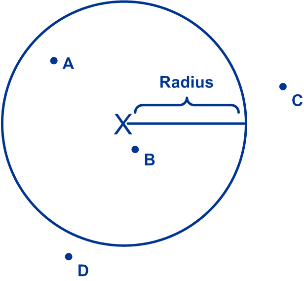
Closest Site performs a radial analysis, which is a process of drawing a circle around a given geographical point and finding sites within that circle. The following diagram illustrates this concept. In this example, the input location is represented by the "X". The area in which to search for sites is defined by the radius. You can specify the radius on a record-by-record basis using the Radius input field. If you do not specify a radius in the Radius input field, then the default radius, specified in the Closest Site options, is used. Given the radius in this example, two sites would be returned for this location: site A and site B. Sites C and D would not be returned because they are outside the search area defined by the radius. If you were to expand the search radius, sites C and D could be returned. Likewise, you could shrink the search radius so that only site B would be returned.

Keep in mind that there can be some variance in the calculations performed by Closest Site. These potential variances increase as the north-south distance between points increases. This is because as you go north or south from the equator, the circumference of each latitude decreases, introducing variance to the calculation. The following table shows the maximum variance for points oriented north or south of the base point, which have the largest potential variance.
|
North/South Distance |
Maximum Variance |
|---|---|
|
50 miles |
0.25% (0.1 miles) |
|
200 miles |
0.9% (1.8 miles) |
|
400 miles |
1.25% (5 miles) |
|
1000 miles |
1.9% (19 miles) |
Variance exists only in calculations of north-south distance, not east-west distance, because longitudes always have the same circumference. No matter where two points are on the Earth, when you calculate the east-west distance, the calculation will always be correct.