| Name | Type | Use | Default | Fixed | Annotation |
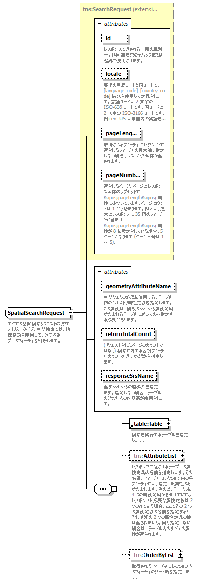
| id | xsd:string | optional | | | | documentation | | レスポンスで返される一意の識別子。非同期要求のデバッグまたは追跡で使用されます。 |
|
| locale | xsd:string | optional | | | | documentation | | 要求の言語コードと国コードで、[language_code]_[country_code] 構文を使用して定義されます。言語コードは 2 文字の ISO-639 コードです。国コードは 2 文字の ISO-3166 コードです。例: en_US は米国内の英語を意味します。 |
|
| pageLength | xsd:int | optional | | | | documentation | | 取得されるフィーチャ コレクションで返されるフィーチャの最大数。指定しない場合、レスポンス全体が返されます。 |
|
| pageNumber | xsd:int | optional | 1 | | | documentation | | 返されるページ。ページはレスポンス全体のサブセットで、'pageLength' 属性に基づいています。ページ カウントは 1 から始まります。例えば、通常はレスポンスに 35 個のフィーチャが含まれ、'pageLength' 属性が 8 に設定されている場合、5 ページになります (ページ番号は 1 ~ 5)。 |
|
| geometryAttributeName | xsd:string | optional | | | | documentation | | 空間クエリの処理に使用する、テーブル内のジオメトリ属性定義を指定します。この属性は、複数のジオメトリ属性定義が含まれるテーブルに対してのみ指定する必要があります。 |
|
| returnTotalCount | xsd:boolean | optional | false | | | documentation | | (リクエストされたページのカウントではなく) 検索に対する合計フィーチャ カウントを返すかどうかを指定します。 |
|
| responseSrsName | xsd:string | optional | | | | documentation | | 返すジオメトリの座標系を指定します。指定しない場合、テーブルのジオメトリの座標系が使用されます。 |
|