| diagram |
 |
| namespace |
http://www.mapinfo.com/midev/service/mapping/v1 |
| type |
extension of tns:MapRenderRequest |
| properties |
| base | tns:MapRenderRequest |
|
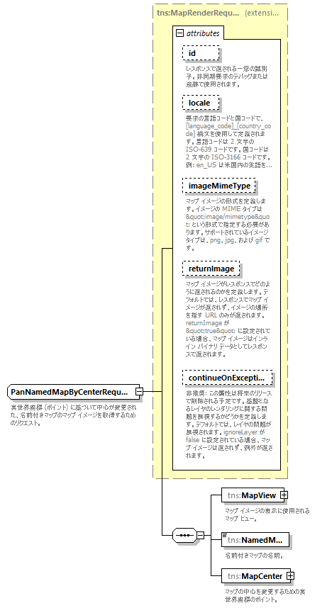
| children |
tns:MapView tns:NamedMap tns:MapCenter |
| used by |
|
| attributes |
| Name | Type | Use | Default | Fixed | Annotation | | id | xsd:string | optional | | | | documentation | | レスポンスで返される一意の識別子。非同期要求のデバッグまたは追跡で使用されます。 |
| | locale | xsd:string | optional | | | | documentation | | 要求の言語コードと国コードで、[language_code]_[country_code] 構文を使用して定義されます。言語コードは 2 文字の ISO-639 コードです。国コードは 2 文字の ISO-3166 コードです。例: en_US は米国内の英語を意味します。 |
| | imageMimeType | xsd:string | optional | image/png | | | documentation | | マップ イメージの形式を定義します。イメージの MIME タイプは "image/mimetype" という形式で指定する必要があります。サポートされているイメージ タイプは、png、jpg、および gif です。 |
| | returnImage | xsd:boolean | optional | false | | | documentation | | マップ イメージがレスポンスでどのように返されるのかを定義します。デフォルトでは、レスポンスでマップ イメージが返されず、イメージの場所を指す URL のみが返されます。returnImage が "true" に設定されている場合、マップ イメージはインライン バイナリ データとしてレスポンスで返されます。 |
| | continueOnException | xsd:boolean | optional | true | | | documentation | | 非推奨: この属性は将来のリリースで削除される予定です。基盤となるレイヤのレンダリングに関する問題を無視するかどうかを定義します。デフォルトでは、レイヤの問題が無視されます。ignoreLayer が false に設定されている場合、マップ イメージは返されず、例外が返されます。 |
|
|
| annotation |
| documentation | | 実世界座標 (ポイント) に基づいて中心が変更された、名前付きマップのマップ イメージを取得するためのリクエスト。 |
|