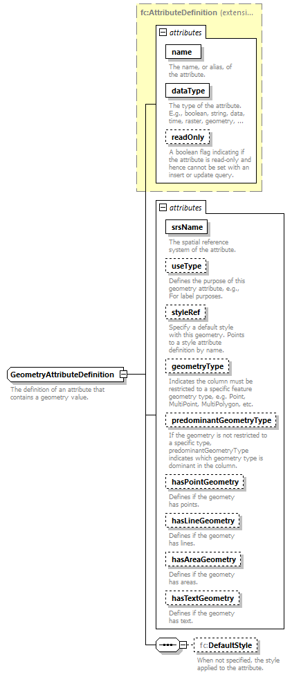
complexType GeometryAttributeDefinition
diagram mapping_p585.png
namespace http://www.mapinfo.com/midev/service/featurecollection/v1
type extension of fc:AttributeDefinition
properties
base fc:AttributeDefinition
children fc:DefaultStyle
attributes
Name  Type  Use  Default  Fixed  Annotation
name  xsd:string  required      
documentation
The name, or alias, of the attribute.
dataType  fc:AttributeDataType  required      
documentation
The type of the attribute. E.g., boolean, string, data, time, raster, geometry, etc.
readOnly  xsd:boolean        
documentation
A boolean flag indicating if the attribute is read-only and hence cannot be set with an insert or update query.
srsName  xsd:string  required      
documentation
The spatial reference system of the attribute.
useType  fc:UseType  optional      
documentation
Defines the purpose of this geometry attribute, e.g., For label purposes.
styleRef  xsd:string  optional      
documentation
Specify a default style with this geometry. Points to a style attribute definition by name.
geometryType  fc:GeometryDataType  optional      
documentation
Indicates the column must be restricted to a specific feature geometry type, e.g. Point, MultiPoint, MultiPolygon, etc.
predominantGeometryType  fc:GeometryDataType  optional      
documentation
If the geometry is not restricted to a specific type, predominantGeometryType indicates which geometry type is dominant in the column.
hasPointGeometry  xsd:boolean  optional      
documentation
Defines if the geomety has points.
hasLineGeometry  xsd:boolean  optional      
documentation
Defines if the geomety has lines.
hasAreaGeometry  xsd:boolean  optional      
documentation
Defines if the geomety has areas.
hasTextGeometry  xsd:boolean  optional      
documentation
Defines if the geomety has text.
annotation
documentation
The definition of an attribute that contains a geometry value.

attribute GeometryAttributeDefinition/@srsName
type xsd:string
properties
use required
annotation
documentation
The spatial reference system of the attribute.

attribute GeometryAttributeDefinition/@useType
type fc:UseType
properties
use optional
facets
Kind Value Annotation
enumeration Feature
enumeration Label
enumeration Unspecified
annotation
documentation
Defines the purpose of this geometry attribute, e.g., For label purposes.

attribute GeometryAttributeDefinition/@styleRef
type xsd:string
properties
use optional
annotation
documentation
Specify a default style with this geometry. Points to a style attribute definition by name.

attribute GeometryAttributeDefinition/@geometryType
type fc:GeometryDataType
properties
use optional
facets
Kind Value Annotation
enumeration Point
enumeration MultiPoint
enumeration MultiCurve
enumeration MultiPolygon
enumeration MultiFeatureGeometry
enumeration LegacyText
enumeration Envelope
annotation
documentation
Indicates the column must be restricted to a specific feature geometry type, e.g. Point, MultiPoint, MultiPolygon, etc.

attribute GeometryAttributeDefinition/@predominantGeometryType
type fc:GeometryDataType
properties
use optional
facets
Kind Value Annotation
enumeration Point
enumeration MultiPoint
enumeration MultiCurve
enumeration MultiPolygon
enumeration MultiFeatureGeometry
enumeration LegacyText
enumeration Envelope
annotation
documentation
If the geometry is not restricted to a specific type, predominantGeometryType indicates which geometry type is dominant in the column.

attribute GeometryAttributeDefinition/@hasPointGeometry
type xsd:boolean
properties
use optional
annotation
documentation
Defines if the geomety has points.

attribute GeometryAttributeDefinition/@hasLineGeometry
type xsd:boolean
properties
use optional
annotation
documentation
Defines if the geomety has lines.

attribute GeometryAttributeDefinition/@hasAreaGeometry
type xsd:boolean
properties
use optional
annotation
documentation
Defines if the geomety has areas.

attribute GeometryAttributeDefinition/@hasTextGeometry
type xsd:boolean
properties
use optional
annotation
documentation
Defines if the geomety has text.

element GeometryAttributeDefinition/DefaultStyle
diagram mapping_p586.png
namespace http://www.mapinfo.com/midev/service/featurecollection/v1
type tns:Style
properties
minOcc 0
maxOcc 1
content complex
annotation
documentation
When not specified, the style applied to the attribute.


© 2007, 2020 Precisely. All rights reserved. support.precisely.com