| diagram | 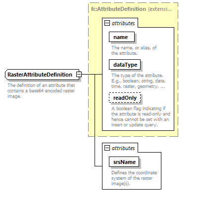 |
||||||||||||||||||||||||||||||||||||||
| namespace | http://www.mapinfo.com/midev/service/featurecollection/v1 | ||||||||||||||||||||||||||||||||||||||
| type | extension of fc:AttributeDefinition | ||||||||||||||||||||||||||||||||||||||
| properties |
|
||||||||||||||||||||||||||||||||||||||
| attributes |
|
||||||||||||||||||||||||||||||||||||||
| annotation |
|
attribute RasterAttributeDefinition/@srsName
| type | xsd:string | ||
| properties |
|
||
| annotation |
|
| © 2007, 2020 Precisely. All rights reserved. | support.precisely.com |