
Address Point Interpolation
Address point interpolation is a patented process that results in a more accurate interpolated point. It improves upon regular street segment interpolation by using point data in the interpolation process, as opposed to using street segments alone.
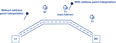
The following illustration shows how address point interpolation works. In the example, the input house number is 71. The Geocode dataset contains address points for 67 and 77. The street segment has a range of 11 to 501. With address point interpolation, the GeoCode API performs the interpolation for the input house number 71 using the points of 67 and 77. Without address point interpolation, the GeoCode API performs the interpolation with the street segment end points of 11 and 501, resulting in a far less accurate result.
The following table provides information on how to implement address point interpolation.
| REST API | Feature Implementation |
|---|---|
|
|
|
For more details, see GeoCode POST Request.