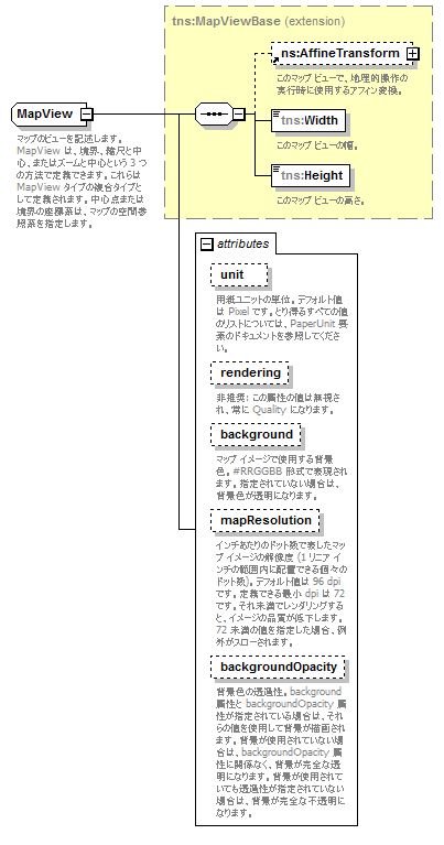
complexType MapView
diagram mapping_p245.png
namespace http://www.mapinfo.com/midev/service/mapping/v1
type extension of tns:MapViewBase
properties
base tns:MapViewBase
abstract true
children tns:AffineTransform tns:Width tns:Height
used by
elements ConvertPointToXYRequest/MapView ConvertXYToPointRequest/MapView ConvertXYToLineStringRequest/MapView ConvertXYToEnvelopeRequest/MapView ConvertXYToPolygonRequest/MapView GetLengthRequest/MapView RenderNamedMapRequest/MapView RenderInlineNamedMapRequest/MapView RenderNamedMapWithOverlayRequest/MapView RenderMapRequest/MapView ConvertMapViewRequest/MapView ConvertMapViewResponse/MapView GetMapCenterRequest/MapView GetMapScaleRequest/MapView GetMapZoomLevelRequest/MapView GetMapBoundsRequest/MapView ZoomNamedMapByScaleRequest/MapView ZoomNamedMapByLevelRequest/MapView ZoomNamedMapByWindowRequest/MapView PanNamedMapByXYRequest/MapView PanNamedMapByCenterRequest/MapView MapImage/MapView
complexTypes BoundsMapView DefaultMapView ScaleAndCenterMapView ZoomAndCenterMapView
attributes
Name  Type  Use  Default  Fixed  Annotation
unit  tns:PaperUnit  optional  Pixel    
documentation
用紙ユニットの単位。デフォルト値は Pixel です。とり得るすべての値のリストについては、PaperUnit 要素のドキュメントを参照してください。
rendering  tns:Rendering  optional  Speed    
appinfo
非推奨
documentation
非推奨: この属性の値は無視され、常に Quality になります。
background  xsd:string  optional      
documentation
マップ イメージで使用する背景色。#RRGGBB 形式で表現されます。指定されていない場合は、背景色が透明になります。
mapResolution  xsd:int  optional      
documentation
インチあたりのドット数で表したマップ イメージの解像度 (1 リニア インチの範囲内に配置できる個々のドット数)。デフォルト値は 96 dpi です。定義できる最小 dpi は 72 です。それ未満でレンダリングすると、イメージの品質が低下します。72 未満の値を指定した場合、例外がスローされます。
backgroundOpacity  xsd:double  optional      
documentation
背景色の透過性。background 属性と backgroundOpacity 属性が指定されている場合は、それらの値を使用して背景が描画されます。背景が使用されていない場合は、backgroundOpacity 属性に関係なく、背景が完全な透明になります。背景が使用されていても透過性が指定されていない場合は、背景が完全な不透明になります。
annotation
documentation
マップのビューを記述します。MapView は、境界、縮尺と中心、またはズームと中心という 3 つの方法で定義できます。これらは MapView タイプの複合タイプとして定義されます。中心点または境界の座標系は、マップの空間参照系を指定します。

attribute MapView/@unit
type tns:PaperUnit
properties
use optional
default Pixel
facets
Kind Value Annotation
enumeration Centimeter
documentation
用紙距離単位: センチメートル。
enumeration Inch
documentation
用紙距離単位: インチ。
enumeration Millimeter
documentation
用紙距離単位: ミリメートル。
enumeration Pica
documentation
用紙距離単位: パイカ。
enumeration Point
documentation
用紙距離単位: ポイント。1ポイントは 1/72 インチです。
enumeration Pixel
documentation
用紙距離単位: ピクセル。
enumeration Twip
documentation
用紙距離単位: トゥイップ。1トゥイップは 1/1440 インチです。
enumeration Meter
documentation
用紙距離単位: メートル。
annotation
documentation
用紙ユニットの単位。デフォルト値は Pixel です。とり得るすべての値のリストについては、PaperUnit 要素のドキュメントを参照してください。

attribute MapView/@rendering
type tns:Rendering
properties
use optional
default Speed
facets
Kind Value Annotation
enumeration Speed
documentation
できるだけ高速なタイプのレンダリングを指定します。アンチエイリアスを使用しません。
enumeration Quality
documentation
できるだけ優れた品質のレンダリングを指定します。アンチエイリアスを使用します。
annotation
appinfo
非推奨
documentation
非推奨: この属性の値は無視され、常に Quality になります。

attribute MapView/@background
type xsd:string
properties
use optional
annotation
documentation
マップ イメージで使用する背景色。#RRGGBB 形式で表現されます。指定されていない場合は、背景色が透明になります。

attribute MapView/@mapResolution
type xsd:int
properties
use optional
annotation
documentation
インチあたりのドット数で表したマップ イメージの解像度 (1 リニア インチの範囲内に配置できる個々のドット数)。デフォルト値は 96 dpi です。定義できる最小 dpi は 72 です。それ未満でレンダリングすると、イメージの品質が低下します。72 未満の値を指定した場合、例外がスローされます。

attribute MapView/@backgroundOpacity
type xsd:double
properties
use optional
annotation
documentation
背景色の透過性。background 属性と backgroundOpacity 属性が指定されている場合は、それらの値を使用して背景が描画されます。背景が使用されていない場合は、backgroundOpacity 属性に関係なく、背景が完全な透明になります。背景が使用されていても透過性が指定されていない場合は、背景が完全な不透明になります。


XML Schema documentation generated by XMLSpy Schema Editor http://www.altova.com/xmlspy