
Request Parameters
- points — The input coordinates or multiple input coordinates to be reverse geocoded. Required.
- preferences — The matching options. Optional.
| Parameter Name | Description | Usage |
|---|---|---|
| points an array object containing both a geometry object and a country code string: | ||
| country (String) | Indicates the country to search for the reverse geocode result, specified using an ISO country code or country name. For country codes, see Geocode Premium: Country Reference Listing and ISO 3166-1 Country Codes. | Optional |
| geometry object, consisting of the following elements: | ||
| coordinates (Double) | Specifies the x, y input coordinates, where x=longitude and y=latitude. For example: [ -105.25175, 40.024494 ] | Required |
| type (String) | Indicates the type of geographic entity the input coordinates represent.
|
Optional |
| crs (String) | Indicates the coordinate reference system used for the input coordinates. The
format must be the European Petroleum Survey Group (EPSG) code or the SRID code.
Default = EPSG:4326. Specify the coordinate reference system in the
format codespace:code. |
Optional |
|
preferences object,
consisting of the following elements. Note: Only the following elements in the
preferences object are applicable to the Reverse Geocode
service. Note: To override the default value of a
preferences element for a specific country, specify the
key/value pair in the customPreferences object, with the key
constant preceded by the ISO-3166 3-character country code plus period. For
example: DEU.streetOffset. |
||
| fallbackToGeographic | Specifies whether to attempt to determine a geographic region centroid when an
address-level reverse geocode cannot be determined.
|
Optional |
| fallbackToPostal | Specifies whether to attempt to determine a post code centroid when an
address-level reverse geocode cannot be determined.
|
Optional |
| FALLBACK_TO_WORLD | StringSpecifies whether to use the World Geocoder (XWG) to determine a reverse
geocode when either a country geocoder is not installed or a country geocoder is
installed without a Geocode dataset. The World Geocoder (XWG) may return either a
postal or geographic reverse geocode depending on the level of support in the XWG
Geocode dataset.
|
Optional |
| clientLocale (String) | This field is used for a country that has multiple languages to determine the
preferred order of language candidates. The locale must be specified in the format
"cc_CC", where "cc" is the language and "CC" is the ISO 3166-1 Alpha-2 code, such
as: en_US, fr_CA or fr_FR. For example, Egypt supports both english and arabic. The clientLocale field could be set to either english-first (en-EG) or arabic-first (ar-EG). Note: For a listing of ISO Alpha-2 country codes, see
Geocode Premium: Country Reference Listing and ISO 3166-1 Country Codes. |
Optional |
| clientCoordSysName (String) | Specifies the coordinate system that you want to convert the geometry to. The
format must be the European Petroleum Survey Group (EPSG) code or the SRID code.
Default = EPSG:4326. Specify the coordinate reference system in
the format |
Optional |
| streetOffset (Double) | Indicates the offset distance from the street segments to use in street-level
geocoding. The distance is specified in the units you specify in the
streetOffsetUnits option. Default value = 7 meters. The offset distance is used in street-level geocoding to prevent the geocode from being in the middle of a street. It compensates for the fact that street-level geocoding returns a latitude and longitude point in the center of the street where the address is located. Since the building represented by an address is not on the street itself, you do not want the geocode for an address to be a point on the street. Instead, you want the geocode to represent the location of the building which sits next to the street. For example, an offset of 50 feet means that the geocode will represent a point 50 feet back from the center of the street. The distance is calculated perpendicular to the portion of the street segment for the address. Offset is also used to prevent addresses across the street from each other from being given the same point. The following diagram shows an offset point in relation to the original point. 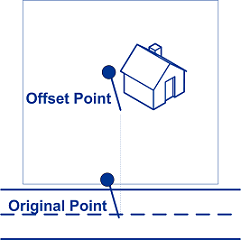 |
Optional |
| customPreferences (Map<String key, String value>) | Specifies the country-specific input preferences. This object can be used to specify:
To override the default value for a specific country, precede the key constant with the ISO-3 country code plus period, and then specify the value. Custom country input options are available for the following countries: |
Optional |
|
returnFieldsDescriptor object of type
ReturnsFieldsDescriptor. Controls the return of additional data
on a candidate. By default, the extended candidate information is not returned, but
in the cases where more is available, it can be controlled in the following ways:
Note: To override the default value of a
returnFieldsDescriptor element for a specific country,
specify the key/value pair in the customPreferences object,
with the key constant preceded by the ISO-3166 3-character country code plus a
period. For example: " AUS.returnAllCustomFields". |
||
| returnAllCustomFields (Boolean) |
|
Optional |
| returnedCustomFieldKeys (List<String>) | Specifies a list of keys that represent the custom fields to be returned in the
candidate's customFields output. For example:
“CTYST_KEY” or “DATATYPE”. Default: empty.Note:
To specify multiple key/value pairs for a country, use spaces to separate the
names of the custom fields to be returned. For example:
"USA.returnedCustomFieldKeys" : "LAT LON SHORT_CITY".
Candidates which have this information available will include the three custom
fields with these keys in the candidate's customFields
output.Note: Custom fields vary by country. To locate your country's
information, refer to Country-Specific Information to find the corresponding section in the
appendix that provides more details. |
Optional |
| returnMatchDescriptor (Boolean) |
|
Optional |
| returnStreetAddressFields (Boolean) |
|
Optional |
| returnUnitInformation (Boolean) |
|
Optional |