
Japan (JPN)
This chapter defines the supported Geocode datasets, operations, and input and output field information for Japan.
Supported Geocode Datasets
The following table lists the supported Geocode dataset(s) with the available geocoding levels for Japan.
| Geocode Dataset | Maximum Precision | Postcodes | Language | Geocode Level |
|---|---|---|---|---|
| IPC | Address Points | Yes | Japanese, latinized Japanese | Premium & Advanced |
Supported Operations
- Geocoding—Takes one or more addresses as input and returns latitude/longitude coordinates and other information.
- Reverse Geocoding—Takes one or more latitude and longitude coordinates as input and returns the address of the location.
Input Fields
Japanese addresses may contain some or all of the following address elements.
| Field Name Parameter | Type | Description |
|---|---|---|
| placeName | String | This field is not used. |
| mainAddress | String |
Single Line input—If no other field is populated, then the
mainAddress entry will be treated as a single line input. For
details on single line input for Japanese addresses, see the section "Single Line Format"
below. Street Address—The block and lot number. |
| lastLine | String | The last line of the address. Optional. |
| areaName1 | String | Specifies the prefecture. Optional. |
| areaName2 | String | Specifies the city (shi). Optional. |
| areaName3 | String | Specifies the municipality subdivision (oaza). Optional. |
| areaName4 | String | Specifies the city district (chome). Optional. |
| postalCode | String | Japan uses a seven-digit numeric postal code system in the format: 999-9999. Optional. |
| country | String | ISO 3166-1 Alpha-3 country code or country name. For Japan, the country code is JPN. Required for forward geocoding. |
Address Guidelines for Japan
For information on Japanese addresses, see the Japan Post website: http://www.post.japanpost.jp.
A typical Japanese address looks like this:

The elements of this address are described in the following table.
|
Address Element |
Field Name |
Example |
|---|---|---|
|
Prefecture |
areaName1 |
|
|
City (Shi) |
areaName2 |
|
|
Municipality Subdivision (Oaza) |
areaName3 |
|
|
City District (Chome) |
areaName4 |
|
|
Block/lot number |
mainAddress |
Block and lot numbers are the most specific address elements. Japanese addresses do not typically have street names. |


For multiline addresses in Kanji, the general pattern is to enter the postal code on the first line. On the second line, enter the other address elements starting from largest (prefecture) to smallest. The name of the recipient, business, or organization is entered on the third line. For example:
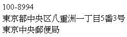
For multiline addresses using Western conventions, the order of address elements is reversed. For example:
Tokyo Central Post Office
5-3, Yaesu 1-Chome
Chuo-ku, Tokyo 100-8994
Single Line Format
Japanese addresses are typically written in single line format, without any delimiters to separate address fields. The typical format is:
[prefecture][city][municipality subdivision][city district][block][lot][other]
- prefecture = ken
- city = shi
- municipality subdivision = oaza
- city district = chome
- block = numbered city block (ban)
- lot = sub blocks or building number (go)
- other = building names, flat numbers, or other identifiers. This information is ignored by the Japan geocoder.
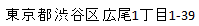
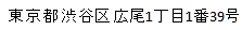
| Example Single Line Japanese Addresses | Description |
|---|---|
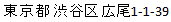
|
Chome, block, and lot separated by a hyphens. |
|
Block and lot separated by hyphen, chome indicated by chome identifier. |
|
Chome, block, and lot separated by their identifiers. |
Custom Options
There are no unique options for Japan.
Parsed Address Output Fields
The following table lists the parsed address fields returned for a candidate located in Japan.
| Field Name | Description |
|---|---|
| mainAddressLine | The street address which may include company name, house number, building names and street names. |
| addressLastLine | The last line of the address. |
| placeName | The building name, place name, Point of Interest (POI), company or firm name associated with the address. |
| areaName1 | The prefecture. |
| areaName2 | The city (shi). |
| areaName3 | The municipality subdivision (oaza). |
| areaName4 | The city district (chome). |
| postCode1 | The first part of the postcode. |
| postCode2 | The second part of the postcode. |
| country | The three-letter ISO 3166-1 Alpha-3 country code. For Japan, the country code is JPN. |
| addressNumber | The lot number. |
| streetName | The street or road name. |
| unitType | The unit type such as APT, STE, etc. |
| unitValue | The unit value/number, such as "3B". |
| customFields | See the following section for the custom field definitions. |
Custom Output Fields
The following table lists the output fields that are unique for Japan. Unless otherwise noted, these fields can be returned for both forward and reverse geocoding.
| Field Name | Description |
|---|---|
| BANCHI JPN.Banchi | The block number. |
| CHOMOKU JPN.Chomoku | The city block number. |
| CHOOAZA JPN.Chooaza | The number for a group of city blocks. |
| GO JPN.Go | The house number. |
| JUSHO_CODE JPN.Jusho Code | A point ID that represents a unique address. |